2009-07-16 40 -74
| Thu 16 Jul 2009 in 40,-74: 40.8846973, -74.9212991 geohashing.info google osm bing/os kml crox |
Location
- Shades of Death Road, Marble Hill, NJ.
Participants
- Jevanyn, at about 10:30PM
Plans
I went to a friend's barbecue that evening, which meant I was about halfway there already. I called up directions on Windows Live Maps on my Motorola Q, and off I went.
Expedition
Seriously, the closer I got, the stranger things got.
The last road sign I saw was for Island Road, the turnoff from US-46. Now if you have been to North Jersey before, you probably know Route 46 as a 6- or 8-lane highway with stores and office buildings on both sides. Not in this neighborhood; US-46 narrows down to a 2-lane road with a traffic light every couple of miles. Island Rd. was literally hiding behind a utility pole. If I hadn't been watching the odometer like a hawk, I would have thought it was a driveway and gone right by. I got out to take pictures of the intersection, expecting there would be little if any light further on. I also took a picture of a large spider guarding the utility pole, but in the darkness my cell phone camera was of little use.
After 100 yards or so, Island road changed to gravel road, which made the minivan a bit unhappy. Further on, the air filled with a fog (I am not making this up!), cutting visibility to about 50 yards. The road itself continued north until it came to a Y-intersection, at what should have been Shades of Death Road itself. To the right (north east) was the entrance to either an auto wrecker or a gravel quarry. To the left, into the inky unknown, lay the geohash.
This road, also gravel, was about as unwelcoming and creepy as you can get. First was the sign that a bridge was out. Then there was the abandoned house. Then there were hints that the road was otherwise blocked up ahead: at 2230 with the fog and no street lights, I couldn't see very far up the road.
I drove as far as I dared, knowing I would have to back up all the way to the Y-intersection, in the dark, to get out. I'd forgotten to bring a flashlight, so trekking ahead on foot had no profit in it.
At some point in here, my cell phone stopped working entirely, so not only could I get any more pictures, but I had no map. I couldn't even use the backlit screen as a makeshift flashlight. There was one more picture taken, I can't remember where or when. With an unresponsive camera, I decided that I'd gotten as close as I could prove, and made my way back to Island Road and Route 46.
(Written 9/25)
Photos
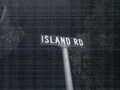
Last sign of civilization
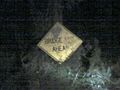
Unfortunately, it does not say "Bridge Club Ahead"
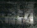
A spooky house! A spooky house!

ZOMG WHAT IS THAT?!? RUN! MUST WARN OTHERS!!


