2009-08-17 50 11
| Mon 17 Aug 2009 in 50,11: 50.9589686, 11.0248295 geohashing.info google osm bing/os kml crox |
Participants
Expedition
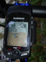
Located in his home town Erfurt, not far from his parents' house, Reinhard at least had to try to visit this geohash. According to the satellite picture, it was close to a small path leading into the forest south of Erfurt, but looked as if it was on private ground. Nevertheless, Reinhard hoped that the satellite picture wasn't positioned exactly, so that he could find the hashpoint on the path (which would clearly have been a Déjà Vu Geohash). So he started after work from Jena and took the well-known route via Bad Berka that he took countless times during his studies, when he travelled between Erfurt an Jena on weekends. The weather was really nice, so that Reinhard enjoyed the ride and arrived near the hashpoint before 8 p.m. after 56 km. His concerns where justified: Leaning his bike with the GPS device at the fence, it was still 4 m to the hashpoint, inside that garden with its small summerhouse. It looked quite unoccupied, so Reinhard accepted the expedition's failure. After that he rode about 200 m through the forest to a popular Italian restaurant with a fabulous view over Erfurt. He would have liked to stop for a pizza there, but that would definitely have made it impossible for him to get on the bike again for the ride home to Jena. So he just ate a banana and rode back, arriving at his home at 10 p.m. in the dark after 107 km.
- Photo Gallery
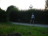
Couldn't get closer than 4 m - bike leaning at the fence to a garden.
There I am, nearly at the hashpoint.
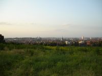
View over Erfurt, not far from the hashpoint.
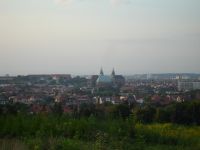
Zoom on the cathedral and the Severi church.


