2009-08-29 34 -118
| Sat 29 Aug 2009 in 34,-118: 34.6278569, -118.9720826 geohashing.info google osm bing/os kml crox |
Location
Near Gorman, in the Angeles National Forest and the Hungry Valley OHV, a couple of miles past the end of Alamo Mountain Loop. On an unnamed hill near McDonald Peak.
Participants
Mike plans to go.
Plans
Leave South L.A. about 10:00 am.
5 North to Smokey Bear Exit. Northwest on Hungry Valley Road about 5 miles to Gold Hill Road. Follow paved Gold Hill Road west. Cross Dry Creek after 5 miles and begin to climb. Pavement ends in another two miles. Keep going. Intersect Alamo Mountain loop road about 12 miles in, possibly near Twin Pines Campground. Left on the loop. In another 3 miles bear left at at T. Go less than a mile to the trailhead (Mt Pinos Road (?)), which should be right about where the more developed road veers left to to Sewart Mountain. Maybe drive or maybe hike a couple of miles to the hash.
Here's a Google Map of the driving part. [Driving Directions]
Expedition
I (Mike) first headed to REI to pick up a GPS. The didn't have the one I wanted, which was disappointing, since this hash was way the hell out in BFE. Suddenly I was feeling less confident about this whole idea. I imagined getting lost and then trapped by bears or eaten by velociraptors. You never know: raptors are sneaky.
Even so, I headed up the 5 Freeway past Magic Mountain and Pyramid Lake, got off on Smokey Bear Rd and started down the forest road toward Piru Creek. A couple of miles it, the access road to Los Padres Forest was fenced off: closed for wildlife restoration. I snapped some photos in case this was the end of the adventure. The forest road paralleled the California Aquaduct, which was dry today.
Back to the freeway and up to village of Gorman, so I could come down on the hash from another angle. I drove through Hungry Valley, the state park designated for dirtbiking, and then into Los Padres Forest. So far so good. Then all the way to Piru Creek. The road beyond Piru was, again, fenced off for habitat restoration. The hills beyond were blackened and bare from a recent forest fire. I was still about 5 miles from the geohash: too far to hoof it. I regretted not bringing a mountain bike.
Some families had driven all the way out to the creek to picnic and play in the calf-deep water. I soaked my feet for a bit, and then headed back down to South Los Angeles.
Tracklog
Photos
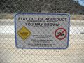
No swimming!
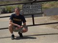
Denied!
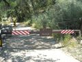
Denied again!
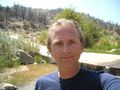
Ahhh!


