2010-03-13 -19 146
| Sat 13 Mar 2010 in -19,146: -19.8458133, 146.6716763 geohashing.info google osm bing/os kml crox |
Location
- 19° 50' 44.93" S, 146° 40' 18.03" E
500m off the Flinders Highway, half way to Charters Towers.
Participants
- Matty K and family
Matty K's Plan

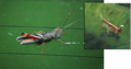
Some time this morning we're going to head out that way, and see how it looks. Thanks to Google Maps I've located a potential dirt track that may lead from the highway, cutting 9/10ths of the off-road journey (see image inset); hopefully making it much easier with my 1¾ and 3½ year olds.
Check back in a few hours to see what went down.
Matty K's Expedition
Failed. Google Map of Locations
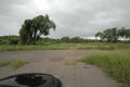
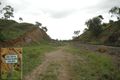
We followed the highway until we found the point I'd identified as most potentially accessible. We took the car off the road and followed what turned out to be a railway maintenance access track. We followed the track east for a few hundred metres, until our way was blocked by overly dense foliage; then we back-tracked and followed it west until it reached a "no further access" point. At no time had we seen a way to get the car over the tracks, nor a gate in the fence on the other side.
We headed back onto the highway and started to drive back towards Townsville when I saw a proper dirt road leading over the train tracks to a gate. The gate was unlocked, so we went through, but a few hundred metres along I realised we were heading towards a homestead. Rather than run the risk of seeing someone and potentially having to explain what the hell we were doing on their property, I chickened out, turned around, and we came home.
- For anyone else attempting it: if I didn't have the girls with me, I would have walked; I was twice only a few (less than 15) minutes' hike from the hashpoint. Don't be deterred by my early failure! –Matty
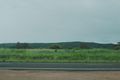
Overview of the general area
Potential access point
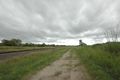
Impassable tracks
No way across
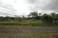
End of the line
Hitch-hikers
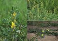
Wildflowers
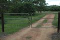
The unlocked gate


