2010-04-26 42 24
| Mon 26 Apr 2010 in 42,24: 42.4258051, 24.7700189 geohashing.info google osm bing/os kml crox |
Contents
[hide]Location
The hashpoint was near the village Dolna Mahala. It is situated in 30km away from Plovdiv, the main city in the area. It is reachable via train or road.
Participants
- Ivan
- Stela
Distances
Distance traveled by train: 34km
Distance traveled by bus: 36km
Distance traveled on foot: 5.5km
Plans
Monday: Ivan: Hey, Stela, have you heared of this "geohashing" thing? It is a game where you go to a random location and bla, bla, bla... (followed by 74722 links to this wiki)
Stela: Cool, let's go!
Ivan: Today's hash is super easy, we can go there in 40 minutes, during the weekend when you are in Plovdiv.
Stela: Cool, if the hash then is not suitable.
Expedition
(At the weekend, but using Monday's coordinates.)
6:30am: Phone alarm rings. Stela: "5 more minutes...". Getting up. Moving around the house. Eating an apple.
7:00am: Waiting for the city bus eating breakfast.
7:10am: Bus is not coming, train is at 7:35... Catching a cab.
7:25am: At the train station. Lots of people waiting for the same train. It is difficult to find empty seats.
7:35am: Train leaving the station.
8:20am: Arriving at Dolna Mahala train station. Not very big station, but 3 trains were waiting there heading in different directions. Other people from our train went to catch the local bus to drive them to the village. We are hardcore and are willing to go there by foot :) (Or too shy to get the same bus)
9:00am: The road passing through the village is the main Plovdiv-Karlovo road. It was recently reconstructed and it had a nice sidewalk. The village was a bit dead at 9am. Nobody around, not even zombies. We didn't have a GPS device, so our only orientation was from stitched-together tiles from Google Maps, put on Ivan's phone. (Note: It is hard to see a blurry map image on a sunlit phone display). We went forward looking for a big crossroad to take the left turn to the field. Instead we reached the end of the village and a church. We went back and took the only other possible road we saw. Walked on it for a few minutes passing around a gypsy suburb and some chickens. Reached a graveyard that was not on the map. The road became a dirt track and it curved right and left exactly as noted. It's the right direction!
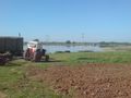
9:20am: Surprise! The road going alongside the water reservoir noted on the map was going along some sort of a cabin and a dog. Big, scary dog. And another surprise - the road ended there! Someone had dug up the field in order to seed the ground. Wtf... Headed back without seeing the water or the hashpoint...
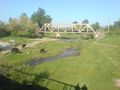
9:40am: We just began to make new plans for the day (it was only the morning after all) when we took a last look behind. Surprise again - the road was there! We were in lower grounds and the perspective had played a trick on our eyes. Okay, turning again. Passing by the scary dog being ready to jump around. It payed us no attention and we continued to the target that was only meters away. We saw the big water channel (empty now) that was noticeable on the maps and when we reached the bend in the road we were there. Hooray!
9:50am: Heading back to the train station. The next train was at 12:00 - 2 hours away - too much. We decided to take the bus to Plovdiv. Walked in the local shop asking for the bus schedule and a bottle of water. There was no water, nothing at all. Only an empty fridge with some bottles of beer. What a shop :)
10:35am: Took the bus.
11:10am: Back in the big city.
Gallery
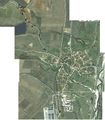
The stiched map. Various points of the other photos are noted.
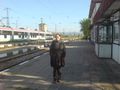
1. Stela at Dolna Mahala train station
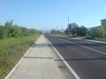
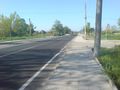
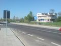
2. The new road between the train station and the village
3. Cows
4. The village "center". Nothing around, not even a village square.
5. Passing by the graveyard.
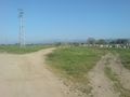
6. On the dirt road.
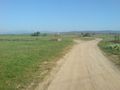
7. Surprise! Big scary dog (doesn't look so big here) and the end of the road.
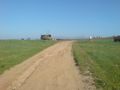
8. First view of the water reservoir.
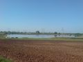
9. The reservoir again.
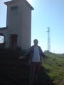
10. Ivan at the hash point. It is near unused electrical transformer.
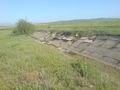
11. The dry channel looks big and dry.
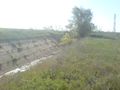
12. The dry channel again.

13. Stela
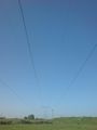
14. We could hear the electricity flowing in these wires. Buzzing about 50Hz.
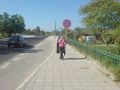
15. Stela at the bus stop.
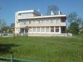
Dolna Mahala town hall.
Village center again.
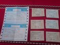
Two big train tickets and smaller bus tickets.


