2010-05-02 45 -123
| Sun 2 May 2010 in 45,-123: 45.3530534, -123.0108065 geohashing.info google osm bing/os kml crox |
Location
Near Bald Peak Road, South of Hillsboro, Oregon
Participants
Plans
Jim looked in the morning and decided that since it was near by, and it was a nice day, he'd head towards it.
Expedition
The comment for this section asks: "How it all turned out?"
The answer is, pretty much the same as most Ag Land geohashes in the Portland area. No access.
It isn't helped by the fact that Jim has become less willing to try for Ambassador ribbons. I'll have to see if I can figure out what is going on there.
The drive there was very pretty. I ended up passing by (yet another) graveyard. I think I really need to do a "Graveyards of Washington County" category. Bald Peak road heads up, and I noticed the elevation rise from 500 feet to 1500 as I went up. I lost track at that point, since I was trying then to drive on twisty roads, looking out over the nearby land.
I also passed a little State Park that I noticed before on a previous geohash. I went it to try to look out over the scenic view, but didn't have much time to get a good look. There also was a large tower which turned out to belong to PGE, the local power company, for communications. Not sure what they do with it, though. They are the power company, not a Telecomm provider.
I then eventually got close to the hashpoint, but found that it appeared to be in a Vineyard. I expected them to be pretty fussy about letting me wander through their field, so I decided not to try to ask them.
I headed back home, where we had guests arriving soon for dinner.
Upon getting home and examining the satellite map carefully, I think I see someone else I might have asked, but it didn't look like that on the ground when I was there. I'll have to figure out how to extract this sort of info, which only makes sense to me after I see it on the ground, so that I can use it at the site.
Photos
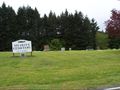
Yet another Washington County graveyard
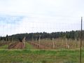
A view of the hashpoint
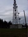
The radio tower


