2010-06-13 45 -123
| Sun 13 Jun 2010 in 45,-123: 45.6961531, -123.1499792 geohashing.info google osm bing/os kml crox |
Location
Adjacent to an apparent logging road near Manning, Oregon
Participants
Plans
I had an appointment earlier in the day, but figured I'd try for it later in the day.
I didn't announce my intentions on the local mailing list since I wasn't sure how tired I would be. However, since no one else said anything, I guess the hash hadn't appealed to anyone else.
Expedition
Access to this hashpoint looked pretty easy, so I went by home to grab some stuff, and decided to bring a four-footed companion with me.
It was a very pretty day as we headed out. We went up to Highway 26 and headed west. It because a two lane highway and the road off towards the hashpoint appeared on the right. I went up it, and started up. I had gotten Google maps to give me the coordinates of the intersections in the roads, but this proved not to be fully needed, as it wasn't full blown logging roads as I expected.
However, partly up the road, I decided it would be good to have the turnoff in the GPS, so I stopped and programmed those coordinates in. As I continued up the road, I checked the GPS. I got to a curve, and it said 200 feet ahead. As I went around the curve, I saw the side road, and then my heart dropped. Two signs denied access through the gate, and there clearly was no one around to ask.
So, I took a few pictures, and turned around and headed for home.
It was a nice drive, however, especially with not having to deal with the traffic of driving into Portland earlier.
Photos
I have a few pictures, but need to upload them.

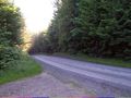
The road up to the hashpoint
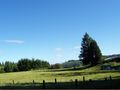
The area below the hashpoint
The area around the hashpoint
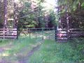
Manning's "Gate of Hashpoint"
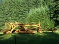
Nearby farm machinery


Achievements
Jim earned the No trespassing consolation prize
|