2010-08-08 -37 144
| Sun 8 Aug 2010 in -37,144: -37.8514438, 144.8988717 geohashing.info google osm bing/os kml crox |
Location
A few metres off the coast on Williamstown beach.
Participants
Stevage. Mitch and D observed and laughed. Ellen sat in the car.
Expedition
I'd been hoping to do an aquatic geohash for a long time. This one was only a few metres off the beach, and in daylight would have been perfect - there's even a bike path running past. At 11pm, it was on the chilly side.
Fresh from the successful Footscray cemetery geohash, we zoomed in on the spot, parking within about 50m. I wandered over to the rocks and saw that I could get to 20m without getting my feet wet. I clipped on my helmet cam, whipped off my jeans, and slipped on the sandals I had brought for the occasion. It is faintly possible that I looked ridiculous, in sandals, undies, ski jacket, and helmet camera attached to a strap around my forehead.
At first, all went well. I delicately hopped from rock to rock, admiring the sludge and mildly nauseating odour. The lights across the water were pretty, and I could see the whole Westgate Bridge lit up. GPS in hand, I made my first steps into the mud. Squelch. Squish. The closer I got, the thicker the mud got, until simply extricating my feet for each step became a major challenge. Retrieving the sandal, even harder... Then I slipped, plunging my GPS underwater in my frantic efforts to regain my balance. Yes, it really is waterproof.
Eventually I got to within 7m, and having great difficulty moving in any direction, I called it "close enough is good enough". I clumsily waded back to shore, quickly dried off (I even remembered to bring a towel!), and drove back home. Mitch caused a few last moments of drama by revealing that he'd locked himself out. Fortunately, a passing PhD student was able to let him in.
[2024 note: it's unclear from the above, but I reached the point late on the 9th, so definitely not a success]
Photos
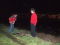
Stevage undresses
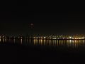
Skyline from the hash
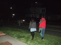
Mitch and Deon return from the excitement


