2010-08-29 38 -77
| Sun 29 Aug 2010 in 38,-77: 38.9542821, -77.1512477 geohashing.info google osm bing/os kml crox |
Location
In a parking lot near the George H. W. Bush Center for Central Intelligence.
Participants
Plans
Google maps showed what looked like a fence around the parking lot, so I kind of expected this to be a no trespassing hash. Especially with the name of the building the parking lot was attached to.
The google maps from York, PA (where I'm staying) to the hashpoint were as follows:
- I-83S
- I-695W
- I-70W
- US-29S
- I-495W
- George Washington Memorial Parkway
- "The exit toward George Bush Center for Intelligence"
- Colonial Farm Road
On Colonial Farm Road, there is also a Colonial Farm, which I decided before leaving was to be my stated destination if asked.
I also had a discussion with a friend about whether or not the "Center for Central Intelligence" was actually the CIA or just a Bush-ism. I figured "Central Intelligence" was a two-word proper noun, and that therefore it was the agency in question. Because of that, I figured the best I would be able to do was pictures of the parking lot from the other side of the fence.
Expedition
The route was as described most of the way there, except for US-29S which has stoplights and is therefore not really a highway.
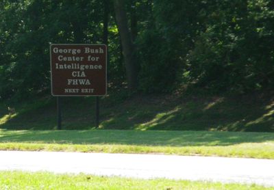
Once I was on the elder GW's memorial parkway, I saw a sign for the exit that google had instructed me to take.
Yes sir, it was what I thought it was.
I took the exit anyway, because Google knows all, right? And Google gave me instructions to turn onto Colonial Farm Road after taking this exit.
Just around the corner and once I was out of sight of the main road behind a screen of trees, I came across a large number of other signs. And a large number of even larger fences and closed gates.
I pulled onto the shoulder and pulled out my directions, so I could look at them with a puzzled face in case any CIA people were watching me, and compared my directions with the densely packed metal mesh in front of me and my memory of the google maps overhead view. The straight through road went into the biggest gate of all, but Google wanted me to take a smaller road to the right. This also had a big gate. There was a smaller road to the left, also gated. All three had forbidding signs forbidding me to enter.
I did not take any pictures of the signs or the gates.
I do, however, think it's time for a bug report to Google Maps.
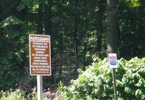
Fortunately, the CIA does make some accommodation for human error and there was a U-turn space before the gates. I turned around, then considered whether or not I should take the eastbound or westbound exit. While considering that, I very unsneakily took a picture of the reason why I did not take any pictures of the gates. Apparently we're not even allowed to take pictures of the parking lot. Which, if the CIA have any secret agents who drive to the Agency offices in their own cars, they don't want them photographed. Or something.
Then, I decided on the westbound exit and retraced my steps to the 495, before proceeding to the reason I was in this graticule in the first place: the Smithsonian!
Achievements
Rhonda earned the No trespassing consolation prize
|

