2011-05-02 49 8
| Mon 2 May 2011 in 49,8: 49.3286159, 8.7660097 geohashing.info google osm bing/os kml crox |
Contents
[hide]Location
On a field near Schatthausen
Participants
Expedition
When I came home at 4 p.m., I decided that today's hashpoint was close enough to reach by bike, so I went on my way.
The first half of the trip was very exhausting, just a steep climb into the Odenwald hills. My cell phone claimed that it didn't have enough memory to calculate the route, So I had to navigate myself using OpenStreetMap data, which worked pretty well.
I knew that the hashpoint was located in the middle of a field, but a lot of the fields around was either fallow or grassy, so I hoped to be able to reach the hashpoint. However, when I approached it, I saw that there it was surrounded by some young cereal plants, and it would have been impossible to go there without damaging the plants.
Disappointed, I cycled onwards to Mauer to take the train back to Heidelberg. I consoled myself with some ice cream.
Tracklog
http://www.everytrail.com/view_trip.php?trip_id=1071770
Photos
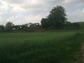
View toward the hashpoint area
