2011-10-09 32 -111
| Sun 9 Oct 2011 in Casa Grande: 32.4032732, -111.6177873 geohashing.info google osm bing/os kml crox |
Location
the boonies near Silverbell Mine
Participants
Expeditions
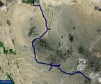
Quite the adventure. During planning, it looked like more of a back road trek than a hike, but those are still fun. Once we got off Red Rock Road (which is two lane dirt/gravel) the barely used "jeep trail" slowly got narrower and fainter. A couple of times we had to get out and look around a bit to find the "road" again, until it just faded to natural scrub. At that point we were still about 2 miles from the geohash point so we did a half mile search for (a) the proper route, (b) something to call driveable or (c) a better way out.
After a total bushwack in the car to get to a real dirt road, we tried a couple other twists and turns to get closer to the geohash point. We got to within a half mile of the geohash point, but decided it was getting late and it was time to explore egress routes while the sun was setting. After 20 miles of hoping the next curve would head us in the right direction, we finally hit civilization and paved farm roads.
Looking back at satellite maps afterward, we found a 2.7 mile utility road route that would have put us back on the original 2 lane dirt road in 10 minutes instead of our 2.5 hour egress adventure.
But, adventures are fun.
Casa Grande, Arizona
