2011-10-09 53 -1

| Sun 9 Oct 2011 in 53,-1: 53.4032732, -1.6177873 geohashing.info google osm bing/os kml crox |
Location
In a field on the edge of Furnace Hill, Ughill, WNW of Sheffield.
Participants
Monty got so far as the field gate.
Plans
On this day, there would be a Hillclimb (cycle race) up to Monsal Head from the very bottom of Monsal Dale, and having some official involvement in the enterprise (in its 81st year), the day's plans necessarily had to involve being in this locale prior to the recreational visit to the day's geohash point.
The weather reports for the weekend had indicated heavy rain across the area throughout the weekend, which would not be ideal for either event, but still had to be suffered, one way or another.
From Monsal Dale (itself to be reached by leaving sheffield along the A625 over Froggat Edge, then through Stoney Middleton and turning off the main roads, southbound, prior to reaching Tideswell) minor roads were to be struck upon up through Bradwell, into the Hope Valley, then up past Ladybower and Sheffield-wards until the Strines road could be taken and then easterly towards Damflask reservoir.
Just before entering Ughill, there is a private road (and public footpath) leading past Platt's Farm and the field within which the geohash point exists. The footpath, and (if conducive to entry) the field, would be walked, all the rest of the journey by car.
Expedition
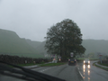
Though damp in Sheffield, the weather during the hill-climb was fair, and patches of blue sky even elicited sun-cast shadows at time during the cycle event, while the wind briefly gusted and breezed along the valley, at times. It was not until shortly after 1pm, and after the last riders had completed the ride, and just before the results were announced and the prizes presented that rain fell upon procedings. At half past one, the solo sport of geohashing was commenced as the rainclouds, having been so courteous to the six score cyclists of the events, gave the lone geohasher a sense that they were here to stay.
Upon reaching the main road through the Hope Valley, it occured to this already proven-foolish geohasher that the narrowly failed 2011-10-04 53 -1 geohash might be pursued, and instead of turning eastwards, a westward direction was taken through Castleton and up Winnat's Pass at about 2pm. This last minute change of plans was to have gone back to the original embark point for the original attempt, but following the original route would have necessitated the crossing of a couple of obvious stream-beds without the promise of a path.
In the worsening weather conditions, the decision was instead made to turn off down to Barber Booth in the Edale valley, with the possibility of walking up the more official paths through the Open Access land, and then along the trail, following wall remains, last barely seen in the late twilight of the original hash attempt. But, at the two or three points where the road and the various likely pathways met, conditions really did not seem any more promising. Given that this retrohash can still be accomplished at a later date, and there's no need to rush things, the unscheduled retro was abandoned before any actual walking was made.
Back down the Edale valley and towards Hope, once more, the original plan was returned to and the trip back towards Sheffield and the Rivelin Valley (only to divert onto The Strines road) was initiated. Upon reaching the junction at Ladybower reservoir, signage was seen to the effect of the Snake Pass being closed "Police Accident", it said, and also (if glanced at correctly) reassurance that the bike-hire business in the Upper Derwent Valley was still open... The latter probably a standard sign rolled out whenever the Snake Pass is closed due to snow. But there was no snow today. Later on, the radio in the car held reports that the closure of the road was due to a small landslide. Doubtless caused by the rains.
Regardless of that largely inconsequential fact, the Platt's Farm private road and footpath was reached at almost exactly 14:40. In an increasingly incessent and annoying drizzle, the short walk began. Passing besides the field before the target one, a huge flock of sheep took fright at the lone geohasher (silly sheep, there was a fence between him and them, and he had no intention on entering this field), and set off for a gap in the wall, leaping through and into the next field. The one in which the hashpoint existed.
Without this ovine incursion (adding to a few isolated fuzzy creatures already in evidence), it might have been trivial and utterly harmless to have climbed the gate and walked up into the field (as had been somewhat hoped would be possible) to accomplish the hashpoint, but with a huge flock of pre-startled sheep milling around behind the stone building (not visible in the images as uploaded, although the building behind which most of them were currently settled is obvious) it was thought judicious not to worry them further (in any sense of the word) and put this hashpoint, too, down as a failure due to access rather than risk any wrath from whichever unknown farmer had an interest in these particular woolly beasts. Actually, it was mostly concern for the beasts themselves. Or perhaps even concern about the beasts, there being enough of them to have made for an impressive stampede, should they have a mind to. But not all geohashes can be legitimately accomplished, and having already proven to not just be a fair-weather hasher there's no reason to go to far to make any point.
Not being public (or Open Access) land, it's unlikely that this is ever, itself, going to be subject to a retro. Unless of course the journey to a later hashpoint involves this particular segment of the Stanage Pole footpath, in which case... you never know.
Tracklog
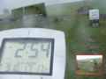
No GPS => No Tracklog.
Photos
The start area of the Hillclimb
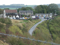
The finish area of the Hillclimb
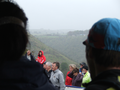
The crowd pays attention
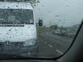
The weather turns wet
Not looking better
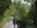
The real walk begins
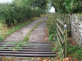
Walkers only
A Gate Too Far


Achievements
TBA, especially with it being a failure.