2011-11-05 40 -111
| Sat 5 Nov 2011 in 40,-111: 40.7960976, -111.8934499 geohashing.info google osm bing/os kml crox |
Location
Near the top of Ensign Peak. Steep terrain, but a road goes pretty close to it.
Participants
Plans
There's snow forecast for Saturday, but if it's not too dangerous I'm going to at least try for it. And if the terrain is too steep then I'll go hike in Ensign Peak Park. Actually I'll probably do that anyway, since I'm there.
It's currently (8:45AM) snowing. Sunset is shortly after 6PM so I'll want to be off the mountain well before then, but as it's such a short hike a 4PM meetup time should still work just fine. If the snow stops by early afternoon I might go for it. If my rental car can't make it up the snow-covered hill safely, I'll turn back. Google claims just under an hour's walk from the bottom of the hill but I don't think their algorithm takes terrain into account... plus if I can't drive safely up the hill I wouldn't trust other people not to slide off the road and hit me if I'm walking. (How slippery is the snow around here? The ski resorts claim fluffy powder.)
As of 12:30 the snow has stopped and the sun is out. Unless the weather gets bad again, I'll probably head there with target arrival shortly before 4PM.
Expedition
It was easy to navigate to the road leading up to ensign peak. The GPS pointed straight at the top of one of the local mountains, and a main road basically went there. More or less.
Once on the mountain, I had to follow Dorchester, Sandhurst, then Twickenham to the very end to get as close as I could drive to the hashpoint. I'd have to figure out at that point if the entire end of the road was claimed private property or if there really was only the one house on the north part of the cul-de-sac.
Dorchester was easy to follow, but at the intersection with Sandhurst I ran into a bit of a problem, in the form of a big gate.
So, plan B. I turned around and went to the entrance to ensign peak park, parked, and started following the trail that google maps showed.
It was a nice hike until the last bit of trail heading south, which was on a ridge leading up to the peak. There was snow on the ground and a pretty stiff wind, and a pretty steep dropoff beside the trail. On the west side. Toward the hashpoint. But I made it to the top of ensign peak and had a look around.
It was pretty clear that I was not getting to the hashpoint from this direction, either. So, I enjoyed the view for a bit longer, inched down the exposed-windblown-ridge-beside-a-cliff part of the trail, and hiked back to my car, having had a nice wander in a strange city and learned a little bit of local history.
Photos
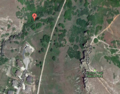
Hashpoint, road, and hiking trail on google maps.
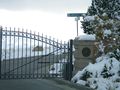
Uh oh, not going by road.
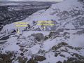
Not going over that cliff, either. This was as close as I got.
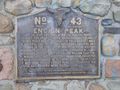
I learned something though!


