2012-02-09 53 -1
| Thu 9 Feb 2012 in 53,-1: 53.5088608, -1.1294899 geohashing.info google osm bing/os kml crox |
Location
In railway yards or aggregate storage area off White Rose Way, Doncaster.
Participants
Monty tested out his scratch-built GPS application for the second time.
Plans
It never looked to be a success (at lest not a legal/safe one), and this was just a second 'proving' trip for the technology.
Method of travel was to be by car, and deliberately on a different route back than the one there. The actual hashpoint was off a road that I do not recall ever personally using, but was just off a route used by yours truly many times, so was accomplished without any maps. Quick glances (when safe to do so, i.e. in stationary traffic) at the laptop screen was to purely be used to double-check the efficacy of the equipment.
On arrival, screenshots were to be taken. (Camera had been left behind, on this occasion, so no actual photos ended up being taken.)
Expedition
Very much as planned, and anticipated. The chosen time of day was the early-morning commute (not too much of a problem, despite being caught going both ways) and the visit to the ATS (tyre sales/fitting) garage revealed an estimated distance to the day's target of just under 100 metres (firstly, why didn't I add a pythagorean combination of the NS and EW offsets, and have I gotten the offsets strictly correct, because that seems rather far, to me).
I was going to leave it at that, but I then decided to go round to the entrance to an open-air aggregate storage depot to see what I could see. The security office at the entrance was unmanned and there appeared to be no activity, but I decided against wandering into the site, uninvited (and without hi-vis vest and other safety gear, moreover). Just as I was leaving, a vehicle went into the site, but there was no real opportunity to flag the driver down, by the time that fact was realised, even if I might have dared to. From this second 'closest' location (or, at least, where I left the laptop in the car, on the roadside, slightly further away than where I'd investigated the security office) it may well have been just over 105 metres away from the destination.
Either way, a failure in Expeditionary terms, but a fairly succesful (to be quantified properly, later) test of the technology.
(Quick pre-submission postscript: Wikimapia measuring indicates 69m difference in the first instance (c.f. 93 metres by Pythagoras, from screen calculations) and 94m difference in the second instance (c.f. 105m caculated from given differences). I think I should revisit the distance calculations. I've probably made an error in the E-W separation, which is dependant upon latitude, rather than in the N-S one, which is largely consistent for any given point on Earth, but the could be something to do with the equatorial bulging as well...)
Tracklog
A 3MB tracklog was created, from more-or-less starting point back to more-or-less end point (started late due to time taken for satellite aquisition, ended early due to concerns for the battery). I see no point posting it all. See the screenshots in the gallery for the salient points.
Photos
Image:20120209 53 -1 ScreenshotA.png | First 'closest' point Image:20120209 53 -1 ScreenshotB.png | Second 'closest' point
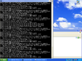
First 'closest' point
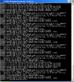
Second 'closest' point


Achievements
None. At all. At least in terms of success.