2012-04-01 29 -81
| Sun 1 Apr 2012 in Daytona Beach, Florida: 29.6803372, -81.2810392 geohashing.info google osm bing/os kml crox |
Expedition
Geohashers
The Plan
I haven't been able to get out and geohash in the last week or two, so I'm itching to get another one under my belt. This one is in Faver-Dykes State Park, presumably just off a side road. $5 per vehicle to get in; the park website states it's an honor box, but why wouldn't you pay?
Aiming to get there around noon or thereabouts.
The Adventure
Really, the entire planning felt like a belabored joke. We had realized about twenty minutes into the drive that the digital camera was left at home, as well as the actual coordinates we were driving to. Thankfully, smartphones are a thing, and both issues were solved before long. Upon arriving, we were more than a bit confused, as what we thought was the road to the state park was lined with houses. Fortunately, we continued on, at which point the state park the road was named after came into sight two miles later.
We paid our honor fee into the park, and that's around the time the jokes started compounding. We parked in a picnic area near a scenic river and consulted our maps. Google claimed that with a few turns and a campground, this was largely a deadend road. The park's maps claimed that there were several roads and trails intertwined. Guess which one we believed. (Guess which one we should have believed. In other words, I know it sounds like an April Fool's joke, but for once Google Maps was actually more accurate than the park's own maps.)
We followed the roads and began wondering where all these other roads and trails were supposed to be. Similarly, I was wondering where all the shade was supposed to be, as every picture involved huge amounts of tree cover; not only was this not the case, but as it was around 11:30 in the morning, the sun was nice and bright overhead. Fortunately, sunscreen was brought, although it wasn't enough to keep me from being burnt. We made it to the campground, at which point we were a bit less than amused, as we should have passed three other trails at that point, and the campground was a looping road which was only met by another looping nature trail. Dejected, we walked back.
This time, however, we found one of the trails on the map! It turns out, on their public maps, the vast majority of roads and trails are... their private service roads. Off-limits to the public. At that point, we were a bit annoyed, but there was hardly a sign of anything resembling a park ranger, so we continued down that service road.
Once we hit an intersection of service roads, we stopped to check the GPS to see where the point was... and the answer was not inspiring. A straight line over two miles, assuming the service roads pass relatively nearby it, on trails that might as well have been undocumented, at noon and only liable to get hotter, with two individuals who probably weren't in good enough shape for a minimum four mile hike... we knew when to fold that hand.
There was a glimmer of hope, as there was another dirt road off Phillip's Highway that would have taken us around half a mile to the hashpoint! A dirtroad that was gated off and, unlike a previous hash, I had no intention of jumping this one and walking the rest of the way.
On the other hand, the picnic that was originally destined for a state park, a picnic that was supposed to be eaten in the middle of a state park filled with underbrush and a great deal of bugs that decided they wanted in on the ride, was instead deliciously consumed and enjoyed near a quiet pool back home. It may not have been a geohashing success, but I challenge you to call lunch by the pool a failure.
Gallery
- Photo Gallery
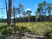
A typical non-urban Florida geohash.
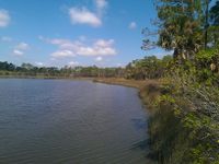
The geohash! If the DJIA appreciated this sport!
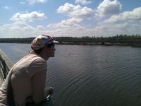
NinjaBait being photogenic near the water.


Achieveables
Dr. Canadian Ninja earned the Admit One Achievement
|