2012-04-10 -35 149

| Tue 10 Apr 2012 in -35,149: -35.1561587, 149.0656454 geohashing.info google osm bing/os kml crox |
Location
WHERE I THOUGHT IT WAS... The back yard (east side) of Wattle Park Uniting Church, beside the line of pine trees; off the Barton Highway just inside in New South Wales after crossing the border from the Australian Capital Territory.
Participants
Plans
1PE
Around 5.30pm, arrive at Wattle Park and 'plant' an ActiveGrohasher poster.
Expedition
1PE #1
I went to the church property and then climbed the barbed wire fence. Something felt wrong, but I went across the back paddock, past the pond, and found the north-south line of trees, and the site looked right.
The problem was, later, that Google was WRONG with the site description so I had been fooled; and I have reported it as such. The property to the south-east is the correct place. In coming days, I will visit there and see the correct place.
Retro expedition - 1PE #2
I revisited tonight, and placed a copy of the poster on the gate of the property; I did not go in, as it was night-time and I was not about to stumble to or past a rural house...
Photos
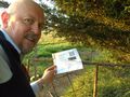
Where the site is NOT.
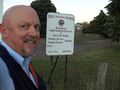
The church where it is NOT.
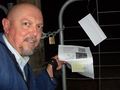
Correct place, late into the evening.

