2012-06-04 54 9
| Mon 4 Jun 2012 in 54,9: 54.0458348, 9.7443343 geohashing.info google osm bing/os kml crox |
Location
Forest near Itzehoher Str./L121 between Waldhütten and Wiedenborstel.
Participants
Expedition
This is my first geohash. I recently downloaded a GPS-app on my Nokia 2710 and wanted to finally try it out.
Around 1900 I drove by car from Kaltenkirchen to the part of the L121 I hoped was closest to the hash. Unfortunately I parked more north than I had planed. That's one of the reasons why my expedition took me to many places but not directly to the hash.
As I expected the hash to be north of my parking place in a small side street I packed my mobile phone, iPod for photos and my trusty katana and started to walk on the street to the north. I already saw that in the east, where the hash should be, there was a fence. I thought I should get as close as possible, so I continued north. Unfortunately my newly acquired app doesn't calculate the distance to the hash. In fact, it just shows my current coordinates, so I continued to the north without paying attention to the numbers and searching for a way to the east.
I found a big gate with a lock on it, so I already thought about giving up, but then I realised that there was a small hole on the left of the gate, where humans could go through. It seems the gate was just for cars. I happily followed the way to the east, but then started to think about the coordinates. They became higher although the target had lower coordinates. Then it dawned on me: I had to go to the west, to reach the target. I thought it's strange, that the hash is west of the street although on google maps it is clearly east of it. So I walked the forest path back to the big street and continued to the north on the other side of the road.
But alas now the north coordinate was getting higher even though it should be lower! That was the moment when it became crystal clear to me how I could find the hash just by looking at my current position. Lower coordinates are to the west and south, higher coordinates are to the north and east.
I walked back to my car and started from the beginning. I thought about the impression I was making on car drivers passing by me on the street. A young man with long hair and a katana on his back walking up and down a road several kilometres away from a city or village. I would have liked to be one of those drivers to see somebody like that on the street. I was reminded of the song "Mit dem Schwert nach Polen, warum Rene" ("With the sword towards Poland, why, Rene") by Die Ärzte.
It was still strange, that the hash was west of my current position, but I shrugged and followed the side street, where I parked in, to the west. When the longitude was right I turned south and dove into the forest. Fortunately there was a path for cars which hadn't been used for years it seemed, but it was still easier to walk on it.
Long story short, I realised that I had parked too far north and ended up at the place where I had planned to park my car in the first place. From there I just had to go east to reach the hashpoint, but there was still the fence. So I searched for the place closest to the point along the fence, made some photos and called it a day returning to my car.
On second thought I could have crawled through the small hole you can see in the photos, but I didn't want to risk to fight some hunters with my katana or stepping on a landmine.
I thought about driving to the hash in the eastern graticule Kiel, but decided against it, because I didn't want to arrive late at home. Is that a Prize Poultry or a No Trespassing Geohash achievement?
It was a nice first geohash and I'm looking forward to the next expeditions and the adventures I might discover on my ways like the two deers I saw today. And who knows, maybe I will also get a more professional GPS device for next time.
Tracklog
Photos
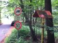
Shady parking in a side street.
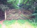
Nothing says "Don't Enter" like a gate with a big lock.
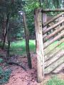
Passageway for people.
Some strange hole in the fence and a small hut nearby. Maybe for observing animals?
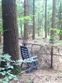
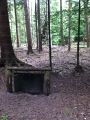
A strange chair in the middle of the forest.
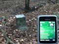
A marker stone near the hashpoint. Whatever it marks...
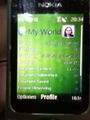
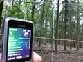
Here you can see the coordinates a bit better.
That's the view to the hashpoint through the fence.


Achievements
Koryu earned the No trespassing consolation prize
|