2012-08-18 19 -155
| Sat 18 Aug 2012 in 19,-155: 19.5667700, -155.1539128 geohashing.info google osm bing/os kml crox |
Location
Near the intersection of Ihope and Peck roads on the outskirts of Mountain View. Although Google's map shows an extension of Peck road leading to the spot, in fact the road extension doesn't exist and the spot is in an impenetrable forest behind a water tank posted with do not enter signs.
Participants
Simon, Leonard, Neil, and Steve.
Plans
The spot's just off the (literal) high point our regular Saturday bicycle ride. How could we not stop?
Expedition
Rode up from Hilo on the Stainback highway and Ihope road. Huff, puff. Quickly found the error in Google's map. The clearing for the water tank was fenced and posted. Behind that, jungle. Decided against bushwacking. We were about 1 arcsec away in both coordinates, or about 40 m total. Took a photo then rode down and away.
Tracklog
Tracklog on Strava: [1]
Photos
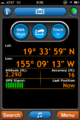
GPS display.
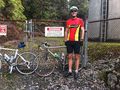
We were there, with cycles, but the fence was posted.


Achievements
Simon earned the Bicycle geohash achievement
|
Simon earned the No trespassing consolation prize
|