2013-07-28 32 -106
| Sun 28 Jul 2013 in Las Cruces: 32.3964593, -106.9850709 geohashing.info google osm bing/os kml crox |
Location
West of Robledo Mountains
Participants
- Fugads with my two kids age 1 and 3.
Plans
Going to attempt this one in the evening while out geocaching in the area.
Expedition
My first attempt at reaching a geohash. Been watching the local hash-points for a while now and this one seemed like a good one to get with the kids while doing a little geocaching in the area as well. We drove up Coralitos ranch road and turned off onto the dirt road which headed towards the geohash. For the first 2 miles the road was in good shape, but after we passed a dilapidated ranch-house and well structure the road was wet and muddy from a recent T-storm. Not having a vehicle suited for long stretches of mud, we had to end our pursuit while still 1.4 miles away. I wasn't prepared for a 3 mile hike with the little ones today. Still a gorgeous evening to be out and a fun area to explore. The Robledo's to the east contain Paleozoic trackways, and the Rough and Ready Hills to the west have some fun sport climbing.
Pictures
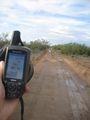
As close as we got
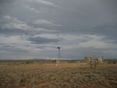
Some interesting structures near our turn-around point

