2013-11-29 19 -155

| Fri 29 Nov 2013 in 19,-155: 19.7362086, -155.5545612 geohashing.info google osm bing/os kml crox |
Location
North Central Hawaii, off the Daniel Inouye Highway.
Participants
- Michael5000 -- Expedition #152
- Mrs.5000
- Mrs.5000's Dad
- Mrs.5000's Mom
Plans
We pored over this one from the aerial imagery. "It's not far from the highway!" "And this road is paved!" "Is it in the park?" "No, and that lava field might be pretty difficult terrain." "Can you tell if it's aa or pahoehoe?" And so on.
Then, paper maps seemed to show that it was on a military reservation. That didn't seem promising. But on the other hand, we would be passing nearby anyway.
Expedition
As we proceeded eastward on the Daniel Inouye Highway, we couldn't help noticing the high fence as we approached the military facilities. Also, the three strands of razor wire on top. Also, the patrol road just inside the fence perimeter. It didn't seem promising.
Our approach to the hashpoint required turning south on a paved Road across from Mauna Kea State Park. When we got there, we found it was gated and marked with a sign saying "Pohakuloa Training Area -- Military Access Only." Soooo....
Photos
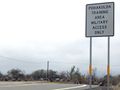
Well that seems fairly definitive.