2013-12-27 41 -87
| Fri 27 Dec 2013 in Chicago: 41.8539767, -87.6075226 geohashing.info google osm bing/os kml crox |
Location
Near the tip of Northerly Island (not an island!) off downtown Chicago.
Participants
Plans
I'll be there around 2 or 2:30 probably, by bike. If you post when you're coming, I can try to adjust though... -- OtherJack (talk) 13:37, 27 December 2013 (EST)
- never mind, more like 4... to give haberdasher a chance! ... -- OtherJack (talk) 14:21, 27 December 2013 (EST)
Expedition (OtherJack)
My dad and I wanted to take advantage of the warm (>0C!) weather in Chicago today and get a bike ride in. When I found out the hashpoint was in a convenient and interesting lakefront park downtown AND another geohasher (Haberdasher) was probably coming, the natural course of action presented itself. Dad didn't want that long a ride however, so the plan was that halfway down or so he'd turn around and go home.
He wanted to leave our family home in Evanston around 12:45pm, so I estimated 2-2:30pm arrival. (Later at one point Haberdasher thought she'd arrive more like 4, so for a time I was thinking I'd just turn around with dad and drive down later for the geohash... but then 4 turned into 3, so the original plan was reinstated.) We left at 1 and rode mostly side streets to Sheridan and Ardmore where we picked up the lakefront path, which was well salted and free of ice and snow, yet quite uncrowded despite the nice sunny day. Great for riding! I guess most people don't think of biking or running out here in winter regardless of the weather.
At Fullerton dad headed back, and then (alas) at Oak deep snow covered the path ahead - we'd anticipated this might be the case, since the trail south of Oak is so close to the water and they wouldn't necessarily salt it. So I took the underpass and headed over through the Gold Coast to Clark, and then cut over to the new Dearborn two-way bike lane closer to the Loop. This added considerable time, and I was glad we'd said 3 instead of 2:30. A stiff southwest headwind was also contributing to the slowness (and the warmth).
But it was really cool to ride the Dearborn lane for the first time, and soon enough I found myself in the south Loop and then rolling under Lake Shore Drive into the museum campus. There was some awesome lake ice by the aquarium leftover from the earlier cold weather, which I stopped to photograph. After that it wasn't hard to find the road across to the planetarium and then down Northerly Island.
After what felt like quite a long traverse of the park-covered "island" (actually a peninsula) I reached a parking lot, behind which loomed a very large construction site with house-high mounds of earth and equipment everywhere. It was a few minutes to 3. I thought, this must be the southern tip I was looking for... and those look like geohashers pulling up in that sedan. But when I talked to them (two middle aged gals) they just turned out to be bird watchers. They were very excited that I was geohashing though. I think they thought it was geocaching. Whatever. Around this time I also learned I needed to be back in Evanston in time for 6pm plans, so I wasn't going to have much time. Luckily, I also found out Haberdasher and company were getting quite close.
Pulled up geohashdroid (I'd forgotten my Garmin back in Seattle) and it seemed very confused about where I was, so I decided to just ride over through the muddy grass to the lakeshore and see if those two figures poking around in the rocks were geohashers. But they weren't either, and then the phone found its bearings and revealed to me that I was still in the MIDDLE of the island, and that the hash was still something like 700m south, i.e. way way into the construction. Darn.
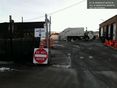
But I figured I'd still wait a little for Haberdasher etc. I walked the bike through lots of raptor-tracked mud back to the small parking lot, where an SUV was just pulling up. Who was in it? Someone was driving and... yes that was Haberdasher in the passenger seat! We introduced ourselves (the other two people turned out to be her parents, whom she was in town to visit) and decided to ride/drive up to the construction entrance, which was basically the closest accessible spot to the hash. After conversation and a photo with the Do Not Enter sign Haberdasher and I figured we'd at least walk into the construction zone and try for the Ambassador achievement. Alas the guy on duty pleasantly denied us permission. I forgot to ask him what they were building. I guess we can come back in a couple years and find out. The Google satellite picture just showed parkland (no dirt or construction) so this must be really recent.
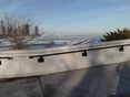
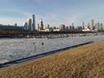
So we strolled over to the harbor side to take a few more ice/harbor/skyline shots and then I headed back. If the 6pm thing hadn't just come up I'd have been happy to stay and chill for longer... sorry Haberdasher and family! The tailwind gave me a nice boost back up the Dearborn lane and then up Clark through the North Side (it was too dark to take the lakefront path) and I managed to get home with about 10 minutes to spare, with the help of a couple Pop-Tarts from a mini mart in Andersonville. I used those minutes to take a deserved shower.
Nice ride and nice (if brief) meetup!
Pictures
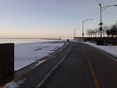
No more lakefront trail :(
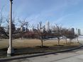
Ice and Navy Pier from the aquarium
Whole bottom of the island is a construction site! I'm in the parking lot at the very end of the road ... @41.8595,-87.6100

Far end of the construction fence
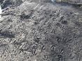
Raptor breeding grounds
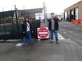
Meetup! No trespassing!


Achievements
Haberdasher and OtherJack earned the No trespassing consolation prize
|
Haberdasher and OtherJack earned the Meet-up achievement
|