2014-01-02 -38 145
| Thu 2 Jan 2014 in -38,145: -38.1819622, 145.1367639 geohashing.info google osm bing/os kml crox |
Location
In a residential property south of Frankston
Participants
Expedition
I got a message from Tom suggesting a ride to the Frankston geohash that day. I was a bit dubious because the map showed the hash to be inside a property and Frankston is not known for its accommodating residents. Also, I had a lunch on with a friend so I could only go after that - and before a dinner with another friend.
Baring these complications, I set off with Tom after lunch at about 2pm. We rode into the headwind through St Kilda and down to the bay. The stiff breeze soon encouraged us to jump on the train at Mentone and continue the journey from Frankston station.
Arriving at the hash 6kms south of Frankston, we noted that the point was on the boundary between the properties. We knocked on the first door and, after briefly summarising geohashing as 'a sort of internet scavanger hunt' asked the male resident if we could stand in his backyard and take a photo of ourselves.
"No you cannot", was the response.
Undeterred, we tried the next house.
"No you cannot", was the response again. The tone, sub-second pause before responding and total lack of curiosity about the geohashing project was identical to the first. Often people are quite intrigued and puzzled by my geohashing explanations, but South Frankston must attract a certain type of defensive and suspicious character... Or perhaps the two samples are not enough to categorise the personalities of an entire suburb.
Regardless, we took photos outside, reckoned we got to within about 10m (not a success) and left the way we came, this time taking advantage of the tail-wind to propel us all the way back home, or, in my case, dinner in Carlton.
Tracklog
Here and here is a route of our journey. Total distance ridden was 100kms.
Photos
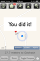
GPS saying we made it
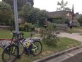
Tom and Bikes
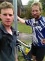
Hashfail faces


