2014-01-12 53 -2
| Sun 12 Jan 2014 in 53,-2: 53.5469398, -2.7559078 geohashing.info google osm bing/os kml crox |
Location
In a little cluster of trees at the end of Ennerdale, in Skelmersdale.
Participants
- Angel should be able to make it with very little problem. Less than a mile from mum's house.
Plans
I'll be heading down there whenever I wake up. Depending on time and weather, might take the scenic route via Harts Lane and Carr Lane, and taking a photo of the location from Ashurst Beacon. Planned achievements: Drag-along, Tron.
Expedition
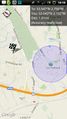
Well, it took less than a minute to walk there. I walked right up to the wall, but my GPS said I was 41 feet away; my marker didn't move from the pavement at the side of the road. So ... I don't know how close I was, but I'm pretty sure it was less than half of the 41 feet that Geohashdroid estimated.
Then as I was uploading my photo, it flashed up with the message saying I'm there within the limits of GPS accuracy. By then I was half way across the road, though, more like 200 feet away. So ... it said I was there when I wasn't, but when I was there (or as close as I could get, given that the hash appears to be right at the edge of a house), it said I was further away. Can I count that?
On the way back, I went the long way around. Headed to the Concourse in the hope of buying razor blades, but I failed on that mission. Arrived ten minutes after they closed. On the other hand, that did mean I took a rather indirect route, so if the hash counts, I've walked a complete loop without crossing or retracing my steps (even when that meant taking a detour because the path between the top and bottom of a bridge was on the wrong side).
Tracklog
Should be available on the Endomondo website if I remembered correctly how to post a link on here. (That's one bit of wiki markup I always seem to mess up)
Photos
This one should be an easy hash for anyone in Skelmersdale. I'll try to make it at some point in the morning.

41 feet was the closest I could get; blocked by a garden fence. @53.5471,-2.7559

