2014-05-01 21 -157
| Thu 1 May 2014 in Oahu East: 21.3118175, -157.9147547 geohashing.info google osm bing/os kml crox |
Location
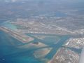
Near Honolulu Airport, just south of the western tip of Mokuoeo Island
Participants
Expedition
Flew out of Seattle before 6am on May 1, landing in Oakland just after 9. A quick check of the geohash points before the flight to Honolulu revealed this point, close to the airport. Is it accessible? Will the plane fly over it? What are the conditions on the ground?
- Likely water - but water far from home... -- Thomcat (talk) @37.7074,-122.2024 09:18, 1 May 2014 (PDT)
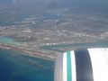
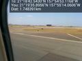
The flight to Honolulu went well, and no we didn't fly over it. We did bank around it, however, enabling me to get these shots with the camera. Once on the ground, I took the phone out of flight mode on the taxiway, I noticed we were not far from the FedEx building, likely our closest point to the geohash.
Some quick inquiries on the ground indicated that the point was in restricted waters, so my geohash expedition ended here. I checked the points daily for the rest of my trip, but none ended up accessible. Next time, Hawai'i.
Photos
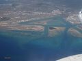
So close... @21.3266,-157.9206


