2015-08-01 42 -78
| Sat 1 Aug 2015 in 42,-78: 42.2679079, -78.7890831 geohashing.info google osm bing/os kml crox |
Contents
[hide]Location
In the woods, by Dobbins Memorial State Park
Participants
- Pedalpusher
- Simon the dog
- Myka the dog
Expedition
Being Saturday, I was hoping to leave the house a bit before 15:00 to make the 16:00 official meetup time, but I was running errands before and ended up leaving a bit after 15:00 instead.
Now, when I go somewhere, I just write down a list of my turns to get to where I'm going and this has never failed me...until today. Once I got onto the back-roads, only half of the intersections had names and the ones that did, just had the cross street. Fortunately, I had a large book map of the state in my car so I used that as well and saw I was still on track. I did have to guess at a few turns though when I got to the end of the road, but I knew the general direction I had to go.
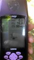
Somehow, I managed to get on the correct road and find a sign for the state park, but I didn't think I was in the parking area closest to the hash. I got out my GPS to help, but of course that had major issues too and took almost 10 minutes to connect to that third, critical satellite. Finally, I saw I was about 1.3 miles away and had a nice trail to follow. But the directions seemed weird and I was mentally turned around so I even pulled out my phone to check the coordinates again to be sure. I ended up coming back to the road and crossing into the area that I was expecting and got close to the hash, but between me and it, was a very thick line of raspberry bushes. I didn't get too scratched up getting through them, but directly on the other side, where the woods opened up, was a posted sign. I could have scooted in the 80 feet required without anyone ever knowing, and I was seriously considering it since it's been so long since I've had an expedition, but I respected the sign.
We walked back on the road to the State forest section by the car and walked around on the trails for another hour or so before heading home. On the way back, I went the other way from how I got there, and found the intersection I was looking for on the way to the hash. I then realized that I had missed my turn and come up the road from the opposite direction I was expecting and that was why I was so confused. I needed my map and still missed 2 more turns anyway due to missing street signs.
Photos
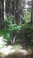
On the way to the hash, we had a nice trail to walk on for a while
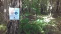
We passed an area that had an ongoing Cornell University study
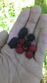
I found a lot of raspberries and some early blackberries. YUM!
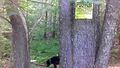
Getting to the hash, we found it posted...
...and so close too!
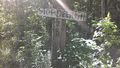
Back on the road, we came across this really weird sign.
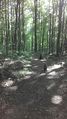
Then, we walked in the State Forest for a while longer before going home.


Ribbons
This user earned the No trespassing consolation prize
|