2015-11-14 52 0
| Sat 14 Nov 2015 in Cambridge, UK: 52.2620441, 0.0104483 geohashing.info google osm bing/os kml crox |
Location
On the edge of a field near the village of Lolworth, just off the A14 outside Cambridge. A public footpath (shown on OS maps but not Google Maps or OpenStreetMap) leads from Lolworth's church to one corner of the field containing the hashpoint, although Google Satellite View shows no evidence at all of that path being marked through the crops in any of the surrounding fields.
Participants
Plans
PaintedJaguar has a very busy day planned, but if time allows will get an early evening Citi 5 bus out to Bar Hill, from where there is a public footpath across a field to Lolworth, and then on to the hashpoint. It's roughly a mile of walking (each way) between the bus stop in Bar Hill and the hashpoint. A futher detour of two-thirds of a mile (each way) will allow 2015-11-14 52 -0 to be attempted as well. Other plans for the day means that there is no certainty at all as to the exact time, but it will be after 4pm, and after dark.
(If anybody wants to drive to this hashpoint, pull off the A14 at junction 28A for an easier approach with much less walking!)
Expedition
PaintedJaguar caught a Citi 5 at approximately 4:45pm, which conveniently has a stop in Bar Hill just next to the footpath to Lolworth. The weather was a pleasant temperature, but very windy, and thankfully the rain that had been pouring down all day had now stopped. The path was not as muddy as might have been expected, given the amount of rain, but the occasional large puddle was waiting in the dark to catch any unsuspecting intrepid explorers who were not watching the path closely enough.
The map suggested a diversion off the footpath just before Lolworth, onto a track towards the target field, was possible, but it turned out that this track was very clearly and very definitely marked as private, so the shortcut was not an option, and route all the way into Lolworth had to be taken. The footpath into the churchyard from the south-west of the village was somehow missed, resulting in an even longer route having to be taken, circling around the village and then approaching the church on a path from the north-west. This path is the one that then turns sharply towards the north-east to head towards the target field, and the one that is only shown on the OS maps, and not on Google, OSM or Satellite View.
The path was initially well signposted off the main road, and easily followed as far as the churchyard. But there was no signpost at all indicating which direction to then cut across the field when heading north-east from the church. A quick analysis of the map showed that the path headed for the left-hand side of some nearby farm buildings, whose lights were visible from the churchyard, and so the left-most lit up building was duly aimed for, cutting straight across the field. The field itself had stubbly remains of crops that had recently been harvested, so no damage was done even if the true line of the footpath (that nobody apart the OS believes exists) was missed.
This field came out on the track that had earlier been marked as private, as expected. The field containing the hashpoint could be seen, with a large line of trees on the right-hand edge, as expected. However, not just one wooden fence, but two wooden fences, both complete with barbed wire, completely prevented access to the field. There was no possibility at all of following the marked-on-the-OS-map-only public footpath any further - it appears that this is a case of the landowner simply not wanting to admit the existence of the public right of way. The closest approach to the hashpoint was achieved at this point, at a distance of 0.21 miles (approx 340 metres). Anybody simply driving down the A14 would have been closer than this!
Rather than crossing the field again, I chose to walk down the (private) track away from the farm back to the public road, where I discovered a rather grand set of brick gateposts, indicating the farm had the name "The Grange Manor House". Something about that name meant I wasn't really surprised at the apparent lack of acccess to the public right of way.
I noticed that the fences lining the field had by now turned into thick hedgerow, so I followed the road around the field for a while to see if there was any way in at all, but when a drainage ditch also appeared between the road and the field, I decided to call it a day, admit failure, and head off to try and acheive 2015-11-14 52 -0 instead.
Photos
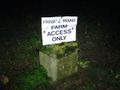
Definitely not allowed down the shortcut track
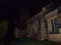
Lolworth church
Two sets of fences and barbed wire block further progress

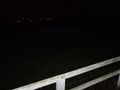
Closet approach (0.21 miles)
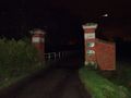
Rather grand gateposts, and a rather grand name. I assume that the bright streak is a speck of dust highlighted by the flash, and it's not the case that I completely failed to notice a giant meteor.


Achievements
PaintedJaguar earned the No trespassing consolation prize
|