2016-07-24 38 -90
| Sun 24 Jul 2016 in 38,-90: 38.3583490, -90.3215809 geohashing.info google osm bing/os kml crox |
Location
A lonely soybean field on the American Bottom in Illinois between Columbia and the Mississippi River
Participants
Kbh3rd and his still lovely bride.
Plans
There were no plans! We went for an afternoon drive, found ourselves on the bottoms, and I suddenly remembered that one of the weekend's meetup points was somewhere nearby. Turned out to be this day's.
Expedition
Having realized that we were accidentally close to the meetup point for the day (see Plans), I broke out the GeoHashing app and let it navigate me to the spot on a road nearest the point. I didn't plan to get out of the car and traipse through a private field to the exact coordinates in 98 degree F (37 C) heat, and I didn't. I guarantee it looks just like what you see in the photo -- the point is in view less than a half mile off.
Read the link about American Bottom above. This area of Pays des Illinois was the bread basket of La Louisiane. This field doesn't look too impressive, but neighboring fields had very nice looking stands of corn and soybeans. This looks like perhaps it had winter wheat that was harvested earlier in the year.
Follow @geohashstl on Twitter for (almost) daily notes on meetup points.
Photos
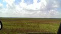
There it is, among the bean plants and old wheat stalks!
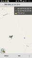
App showing me (blue dot) relative to the target. As close as I got.

