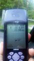
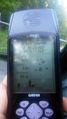
2018-05-29 42 -78
| Tue 29 May 2018 in 42,-78: 42.6114524, -78.8951968 geohashing.info google osm bing/os kml crox |
Contents
[hide]Location
In the woods off Larkin Rd, by Franklin Gulf County Park
Participants
Expedition
The Hash looked to be on private property (although really close to a wide dirt road/driveway) so I initially didn't consider going. However, on closer inspection, I noticed there was a county park on the other side of Larkin Rd that I had never heard of before. Intrigued, I decided to check things out; worst case, I'd park in the Franklin Gulf lot and walk over if there were no posted signs.
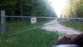
After work, I grabbed the good camera, got the dogs in the car and we drove over. Getting to Larkin, I found the Hash 'driveway', but as expected was posted and gated. I figured I'd stop and get the pictures for the No Trespassing on the way home, after a hike in the park.
Finding the parking area, I was shocked to see the number of cars; I got the last available spot! This place must be WAY more popular than I was thinking. I had found a county park map while looking into the place and was thinking of walking the orange trail. It was really cool and we ended up not running into anyone which was nice. Toward the end of the trail, we met up with the creeks and I explored a little of the fantastic scenery.
Heading back to the car, we just retraced our path in the evening light. I was pretty fortunate not to meet the Forest Ranger on the way out (who must have parked on the road after I had arrived), as I would have gotten in trouble for the loose dogs on the trail (although they usually just give you a warning).
Making a quick stop by the gate to the hash, I got my pictures and then drove home.
Photos
Posted.
As close as I could get.
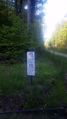
Looks like its gas equipment or a pipeline access for US Energy on Private Property.


Ribbons
Pedalpusher earned the No trespassing consolation prize
|