2018-06-22 46 -114
| Fri 22 Jun 2018 in 46,-114: 46.9966344, -114.2008033 geohashing.info google osm bing/os kml crox |
Location
Likely in a farmer's field near Frenchtown
Participants
Plans
Achieve if possible on the way out of town.
Expedition
Been on vacation a few days in Missoula, relaxing with a pint or three. This geohash is on the way west, and so are we - my friends about to become drag-alongs. I surveyed the map and determined the farmer's road would be the best route, if available.
GPS and vehicle got me to where I needed to walk, but a fence prevented us from going further. Hard to tell from the map, but it looks like the land around the hashpoint is farmed, therefore likely owned.
In hindsight, an attempt up the irrigation canal or down the railroad tracks to the canal may have worked better, but also taken longer. Instead, we got out and over the mountains before the severe thunderstorms hit, with many stops on our way back to Washington.
Tracklog
Photos
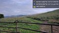
No public acess @46.9943,-114.2027
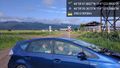
Drag alongs @46.9943,-114.2027

