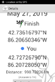
2019-05-27 42 -86
| Mon 27 May 2019 in 42,-86: 42.7361680, -86.2065035 geohashing.info google osm bing/os kml crox |
Location
Lake Michigan shore, Laketown, MI
Participants
Expedition
The hashpoint was just 50m or so above the Lake Michigan waterline, at the edge of a forested dune. We hoped we'd be able to walk there from the Laketown Beach public park half a mile to the south. The shoreline property in this area is mostly privately owned, but the public is legally allowed to walk along the shore below the "ordinary high water mark".
The lake is quite high at the moment and the beach was narrow. Just above the little dune-cliff that marked the high water mark were plenty of signs proclaiming "private beach"; one amusingly said "please keep walking" in deference to the public-access law.
After walking north from the park maybe 1/3 of a km, we came to a spot where the water came right up to the erosion boundary, meaning we'd either have to wade or rock-hop an unknown distance before returning to walkable beach. Since it was now clear that even if we reached the latitude of the hashpoint, we'd be prohibited from walking east from the shoreline and reaching the hashpoint itself. We declared No Tresspassing at that point. It was a lovely visit to the lake nonetheless.
Closest approach
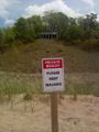
'Please keep walking'
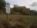
Private beach
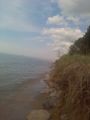
End of our road


Achievements
Mcbaneg (George) and Susanne earned the No trespassing consolation prize
|