2020-07-04 48 -119
| Sat 4 Jul 2020 in Omak: 48.0200255, -119.5078956 geohashing.info google osm bing/os kml crox |
Location
A farmer's field east of Bridgeport.
Participants
Plans
The second of two multihash visits as I travel west.
Expedition
I headed west and stopped at Grand Coulee to stretch my legs. Dam!
From here, it was a little-used road heading west, then a dirt road heading north. A long ways north. Had to stop along the way to allow cattle to clear the road, as I was driving through range area. Saw plenty of deer also - they apparently get along just fine with the cattle, at least until hunting season opens.
I turned left off the dirt road as I was getting close to the geohashpoint and bam, pavement again. After the visit, I would follow this pavement west towards the river, winding down hill eventually to Wenatchee. Had I known, I would have gone in this way - a longer distance but higher rate of speed would have equaled the same length of trip. Though with less cattle & deer.
The geohashpoint was located on land the other side of a paddock, and no crops. What there were, though, were cattlemen and cattle. The former I would have asked to enter their land to visit the point; the latter I didn't feel equipped to negotiate with. I gave a friendly wave and drove on, geohashpoint not visited.
I drive through (or near to) this graticule a few times a year, and this is only my second actual attempt in 8 years. Maybe third time will be the charm.
Tracklog
Photos
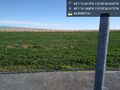
close @48.0195,-119.5075
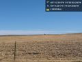
wildlife @48.0193,-119.5360


Achievements
Thomcat earned the Multihash Achievement
|