2021-07-22 42 -78
| Thu 22 Jul 2021 in 42,-78: 42.7278795, -78.6971068 geohashing.info google osm bing/os kml crox |
Contents
[hide]Location
Near a proposed Rails-to-Trails path on the border of Orchard Park and East Aurora
Participants
Expedition
I wasn't sure if I'd be able to get to this one, but I knew there was a possible parking area and a road that went along the proposed trail I might be able to take to get close. Since I was seeing the girlfriend this evening, I figured I could drive over there and use the Mountain bike to get to the hash quicker. We were going to ride bikes later for Ice Cream so I needed to bring the bike anyway.
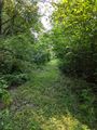
After work, I got everything ready and headed over to the Trail. I rode by bike here on a previous expedition on the other side of this trail, but was prevented access by a large fence. Getting to the parking area, I could see the road I was hoping to use was blocked by a chain and some Posted signs. Figuring the 'parking area' wasn't official and possibly not public, I parked on the road and got the bike out. It was pretty cool going down as things were overgrown and it was like riding down a green tunnel.
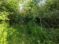
About 3/4ths of the way to the hash, I was stopped short by a tree that had fallen right across the path. Not a giant tree, but all the branches were right on the path and it was far too thick to even crawl through. I did climb up a little to see what I could see on the other side, and it looked very swampy. No going that way. The driveway/road was very close to the trail at this point, but I could also see Posted signs over there too. I guess this expedition is done. I still had about a half hour to play, so I decided to set my alarm and ride out on the path the other way. The trail was maintained and open on this side.
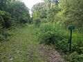
I found a very cool but stony trail. They have taken out the tracks and railroad ties, but not the stones that supported the tracks. The trail went by a creek in a small ravine and also by some VERY nice houses, but it still felt like a woodland trail. Found out later, this is the Erie Cattaraugus Rail Trail they are building that will eventually connect to the Southern part of Western New York and is planned to be about 27 miles starting in Orchard Park.
Getting to my girlfriend's place, we rode to the Niagara River and got Ice Cream at Mississippi Mudds. Yum!
Photos
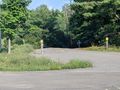
The driveway/road to the hash is blocked.
Getting as close as I could, I was stopped by the tree across the trail...
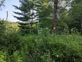
...and to the side, the side by the hash was still posted.
As close as I could get to the hash.
Riding back to the road, I took a picture of the tunnel of plants I was riding through.
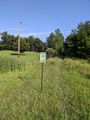
Back on the road, a sign indicating the future trail through here.
The other side of the road, a mile-marker sign indicating a potential 12 miles of trails that are already open.


Ribbons
Pedalpusher earned the No trespassing consolation prize
|