2022-10-20 36 -115
| Thu 20 Oct 2022 in 36,-115: 36.0657423, -115.6488946 geohashing.info google osm bing/os kml crox |
Location
Just outside the Spring Mountains National Recreational Area, Clark County, Nevada
Participants
Expedition
This being my first expedition, I figured I would just get as close as I could to the point and then leave once I took a picture. Since this point was in the middle of the desert, I wasn't expecting much. Google Maps briefly lost the GPS signal as I left the Las Vegas city limits, but got it back when I needed to make a crucial turn (which was great as I don't think I would have noticed the road without it). Once I got on the Pahrump Valley Highway, it was smooth sailing from there (although I did get increasingly worried the farther out I drove).
Quite a few minutes later, Google Maps told me to make a right turn onto a road that would get me within walking distance of the point. The problem was, I missed it. I had to make a U-turn further down the highway, pass that road from the other direction, and then make another U-turn further down that way. Once I got back to where I was told the road was (and parked on the shoulder this time), I realized why I didn't notice it the first time: it barely resembled an actual road from the highway.
The road I was supposed to take looked more like a trail, and I didn't feel comfortable driving on it, nor did I really want to walk the remaining 5 miles. I decided to take a picture of the makeshift entrance to the road and get on my way back home, briefly stopping at a gas station in Blue Diamond (just in case I couldn't reach one in Enterprise). Once I got home, I found out that OSM only shows the road going out as far as I got. Go figure! Regardless, I still had fun getting there, and it was still a great experience as a novice geohasher.
Photos
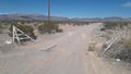
The end of the line for me. The hash point is about 5 miles ahead.
