2025-02-04 48 10
| Tue 4 Feb 2025 in 48,10: 48.1730001, 10.8396768 geohashing.info google osm bing/os kml crox |
Location
Right on the B 17 next to Lagerlechfeld, Germany.
Participants
Plans
Get to Augsburg Hbf, ride the 16:46 train to Lagerlechfeld and walk to the pedestrian path west of the road the hash is on. Then, get back to Lagerlechfeld and take the 18:17 train back to Augsburg.
Expedition
I'd been aware of geohashing for a while (having been aware of xkcd for even longer), but, for one reason or another, never got around to doing one myself. On the 3rd of February, in the hopes of it helping me keep myself accountable, I finally decided to create an account here, and as luck would have it, next day's coordinates seemed pretty promising: Located near a main road not even 25 kilometers south of my hometown, I knew that I would have more than enough time to get there and back, even with my full-time job.
I was excited, but upon further inspection, I noticed something: The hash was not near a main road, it was on it. Right in the middle, between the two lanes, where there was a small strip of grass, but one that would be impossible to get to, probably for the better. Still, I figured that I could get within 20 meters of the hash, and that was good enough for me.
At precisely 16:30 I exited my office and headed towards the train station, stepping onto the platform (and my train) at 16:43. I checked in on Travelynx, sat back and enjoyed the ride. Along the way, a person sitting on the opposite side of the train seemingly noticed two kids starting a fire in the grass and phoned the fire department. I missed it, but it didn't seem that serious, and soon enough, we arrived in Lagerlechfeld, and I got off.
The expedition itself was relatively uneventful, but that was fine with me. Lagerlechfeld turned out to be one of those nice, quiet, small towns, though my path got increasingly depressing, almost, as I had to leave it and enter an industrial park instead. For a good while there was a couple in front of me heading into the same direction, but just as I started to wonder whether they were geohashing as well, they turned into a side street.
I walked for about 15 minutes before arriving. Just as I saw on the map, the geohash was right in the middle of the street, but I did manage to get within 18 meters of it! On my way back I sent my parents a photo I took along the way, which led to me explaining what I was doing via text messages, which in turn led to my fingers feeling like they were about to fall off. Next time, I'll definitely bring some gloves.
Back at the Lagerlechfeld station I still had 20 minutes to kill, so I downloaded StreetComplete hoping to do some OpenStreetMap work, before realizing I was way too tired for that and deciding to just sit around and wait instead. Soon enough, my train arrived, I got on, and just like that, my expedition came to a close.
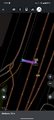
Tracklog
Photos
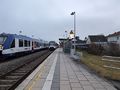
The train from Augsburg leaving Lagerlechfeld after I got off.
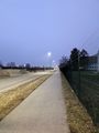
On the way there, I walked alongside the tracks.

A privacy-conscious selfie next to the geohash.

Me pointing to the exact location of the hash.
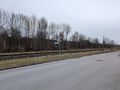
On the way back, I happened to walk alongside a military security zone.
By the time I got back to the Lagerlechfeld train station, it was already dark.
My nearest distance to the geohash.


