File:2019-05-27 51 -1 - google maps satellite 3d.jpg
From Geohashing

Size of this preview: 800 × 421 pixels. Other resolutions: 320 × 168 pixels | 1,178 × 620 pixels.
Original file (1,178 × 620 pixels, file size: 222 KB, MIME type: image/jpeg)
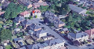
Google Maps (Satellite + 3D) image showing location of the 2019-05-27 51 -1 hashpoint at the end of a suburban cul-de-sac.
File history
Click on a date/time to view the file as it appeared at that time.
| Date/Time | Thumbnail | Dimensions | User | Comment | |
|---|---|---|---|---|---|
| current | 17:00, 30 January 2020 | | 1,178 × 620 (222 KB) | Maintenance script (talk | contribs) |
- You cannot overwrite this file.
File usage
The following page links to this file: