User:Pinecone
I've been to several of the Boston area Saturday meet ups including the first.
I've also invented a version of geohashing which attempts to be more local, described below.
Decihashing
For a description of this system, see Immodest Proposal below.
2008-07-12 Meet up at 4pm at [Location available 07-11].
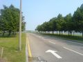
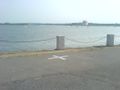
2008-07-05 Meet up at 4pm at Fid Kennedy Ave on the waterfront.
... if I had been awake.
2008-06-28 Meet up at 4pm at 55 Mt Vernon St, Boston between Joy and Walnut.
Planning
No contest today. (42.3,-71.0) weighs in at 0.9 miles and drops us a block from the Boston Gardens. Weather says there's not that much chance of rain.
Boston2 is of interest-- it's nearly out on Deer Island. Also it is the first decihash which begs the question: Are decicules from the neighboring graticule in the running? We ducked the question this time, but for how long? How long??
Todays locations in the Boston graticule:
| DECIHASH | IN DECICULE | DISTANCE FROM "BOSTON" | LOCATION |
| Boston0 | (42.6, -71.3) | 37.7 miles | Always at the graticule hash |
| Boston1 | (42.3, -71.0) | 0.9 miles | 55 Mt Vernon St, Boston - Meet up |
| Boston2 | (42.3, -70.9) | 7.5 miles | Wyman St, Boston |
| Boston3 | (42.4, -71.0) | 8.5 miles | Winthrop St, Melrose |
| Boston4 | (42.2, -71.0) | 8.6 miles | Green Hollow Ln, Boston |
WARNING: The decihash system is an experimental technology. It may become unstable or exploode at any time. Use caution when following it's directions. If it instructs you to pick up any sharp object please report it immediately.
Results
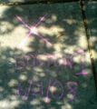
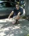
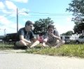
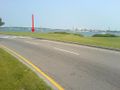
Pinecone and Bret met at 55 Mt Vernon St. which was a historic something or other on Beacon Hill. The actual spot turned out to be across the street at #28. That's right, the house numbers are not monotonic side to side. We marked, we ate cake, but we forgot the game!
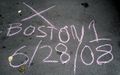
The Spot
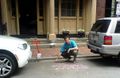
Our host drawing the Spot

AAYEIIII! Forgot to play a game!


2008-06-21 Meet up at 4pm at 92 Coleridge St in Boston
Planning
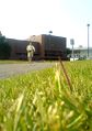
Today's decihash was a hard fought contest with (42.3,-71.0) edging out (42.3,-71.1) 3.5 miles to 3.8. 42.379317,-71.013963 itself is on the edge of a lovely mudflat with the Google Directions to it ending on nearby Coleridge St. Constitution Beach is adjacent which is a fine place if you don't mind the airplanes giving you a haircut.
Boston2 could be worth a visit. It's in front of the Museum of Comparative Zoology on the Harvard main campus.
Results
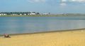
Success! Pinecone and Keith colonized a strategic sidewalk location in East Boston to document this slightly historic event. Thereafter a park was located for the ubiquitous game of something. There was also food and social amusement.
The Spot
Our lovely model indicating the Spot
A game of guile and courage
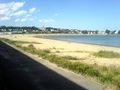
Appears to be a beach
Confirmatory evidence
Planes menacing this beach


2008-06-14 Meet up at 4pm at the corner of University Dr S and University Dr E, Dorchester
Planning
Today's Boston decihash is being hosted by decicule (42.3,-71.0). The location itself is under water 42.306746,-71.038886, but Google's directions to it end at the coast on the campus of the University of Massachusetts. There is a walkway from there that goes to the waterfront. I imagine a cafeteria thereabouts could be used for games afterwards.
Results
Total disaster! Trusted the MBTA public transit system who decided to run buses through the middle of the Gay Pride march. 45 minutes late to the decihash. Will the experimental results still be valid??
The decihash itself was on the perimeter of the University of Massachusetts campus and had a lovely harbor view. I marked the spot and left a game for the next person to finish.
The approach
The decihash
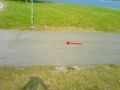
The spot marked X
A human pointing at the spot marked X
Do not be deceived by this impostor
A game was played


An Immodest Proposal
[Could someone familiar with the Google API help me with a reference implementation?]
The Issue
A typical hash is about 30 miles away from you. Ramifications of this:
- A long drive each way for those with car.
- Somewhat more problematic for those without.
- On the social front, you meet a lot of nice people but they live far away from you.
- Nobody is ever going to get the damn Couch Potato ribbon.
- You usually get sent to less populated areas:
- Ironic to burn a lot of oil to go see greenery.
- You don't often get to play with cities.
- In populated graticules you have to find a park to hang out in. This is nice for frisbee but less handy for table games.
- In unpopulated graticules most expeditions are less social club and more hiking trip.
- It's a bigger problem for everyone in the winter.
Reasons I might like something nearer at hand:
- Lacking transport
- Want a local group to socialize with
- Want to play with cities
- The regular hash is someplace god-awful
- I am feeling lazy
Obviously we could just divide up the graticules into smaller pieces, but this would scatter the children of XKCD far and wide. I present a solution here that I think can address these issues.
Decicules and Driving Directions
1. Divide each graticule into tenths called decicules. For example, if I live in graticule (42,-71) then some decicules near me are
| (42.0,-71.0) | (42.0,-71.1) | (42.0,-71.2) | ... | |
| (42.1,-71.0) | (42.1,-71.1) | (42.1,-71.2) | ... | |
| (42.2,-71.0) | (42.2,-71.1) | (42.2,-71.2) | ... | |
| etc. |
2. The day's hash for your graticule will define 10x10 = 100 decihashes which match the hash coordinates except for varying in their tenths digits. For example, if the hash is (42.1357,-71.2468) then some of the decihashes are
| (42.0357,-71.0468) | (42.0357,-71.1468) | (42.0357,-71.2468) | ... | |
| (42.1357,-71.0468) | (42.1357,-71.1468) | (42.1357,-71.2468) | ... | |
| (42.2357,-71.0468) | (42.2357,-71.1468) | (42.2357,-71.2468) | ... | |
| etc. |
3. Pick the urban center you are closest to. There will be four decihashes surrounding that location. For example, if I am near Boston the layout for the above hash would be
| (42.4357,-71.1468) | (42.4357,-71.0468) | |
| Boston | ||
|---|---|---|
| (42.3357,-71.1468) | (42.3357,-71.0468) | |
4. Use Google Directions to find which of these decihashes has the shortest driving distance from the name of your urban center. E.g. "Boston".
5. The end point for that set of driving directions is the Boston decihash for the day.
The reason for that last point is to solve one additional problem. When a hash location is inaccessible, there can be confusion about where to meet up. But when you give Google Directions an inaccessible destination, it gets as close as it can using public roads. That endpoint will always be accessible and unique.
The chosen decihash will usually be within 6 miles of the city center. It doesn't matter where Google Maps thinks "Boston" is, or that you won't be driving the route it finds. What matters is that it's consistent for everyone who checks it.
An Example
| On 5-24-08 the (42,-71) meet up was at 42.126648,-71.547534: | Meanwhile, back in Boston: |


So in this case, those who are able go to the graticule hash in Hopedale, MA while those more local could meet up at 695 William J Day Blvd, Boston which is where the driving directions for the winning decihash end up. If you have plans to visit a decihash on a given day, best to mention it on the graticule wiki page ahead of time.
In a graticule with high population there might be several active decihashes. In my area one would expect Boston, Worcester, and Nashua to have their own contingents.
Honest, this is less complicated than it sounds and an implementation will make it all clear. And you really only need this for urban areas were population density makes sub-meet ups feasible.
Notes
You would name the decihashes in order of distance as: Boston1, Boston2, Boston3, etc. Boston0 would always refer to the actual hash for the graticule that "Boston" is in.
If the decihash is going to suck, you can fall back to Boston2, Boston3, etc or even Boston0. If the graticule hash is going to suck this can also work in the other direction. E.g. "Today's hash is in the middle of a swamp but Boston3 is in the hardware department at Sears. Let's go there!"
The decihash meetups could be overridden by the graticule hash for various reasons:
- If the real hash were close enough to your location name. Say within 20 miles according to the Google directions. For Boston this is a circle between 128 and 495 and is about 10% likely.
- If the weather was significantly better at the real hash. This could work in the other direction too.
You can use any location to define the origin from which to measure a decihash. The Boston decicule would sometimes go to then same location as a Brookline decicule, sometimes not. You would only define a local center if there were a high enough concentration of Our Kind to make it worth while.
An in-town location is likely to pick up some more people just because some can't get out to the hash and because there are just more people in those areas. I'm certainly more willing to meet on a street corner in winter than in the forest.
During weekdays I'm unlikely to be able to road trip to a graticule hash, but it would be great to have a convention to meet up at Boston1 at say, 8pm.
All this is not meant to detract from the preeminence of the original meet up system. Long live the mighty graticule!
Issues
Boundary question: is it allowed to sometimes use a neighboring graticule to get the closest decihash?
Naming convention confusion: Boston graticule vs. Boston decicule. Decicule vs. decihash.
The "dangerous part of town" problem.
Comments?
I think the idea would be considerably more appealing if it were more simplified. You don't need Google routes, city centers, and all that. Just this:
- A decihash is a location that differs from a geohash in only the tenths digits.
Then people can coordinate which decihash to meet at, when they don't have the transportation, the time, or the inclination toward being lost in the woods to get to the actual geohash. If one decihash is inaccessible, there's another one a couple of miles away that isn't.
Decicules can be named after what they contain, as graticules are, not just the nearby city center and a rank-ordered number. For example, there could be (hypothetically, I haven't checked the boundaries) a Cambridge decicule, an Arlington decicule, a Back Bay decicule... And this can be good, because the decihash closest to what Google Maps calls "Boston" might be close in the wrong direction for most people. (Many places south of the center of Boston would be considered "the bad side of town".)
The problems in particular with basing the locations on driving directions:
- You can't check that you're there with a GPS
- "Boston1", "Boston2", etc. would not refer to stable regions, leading to confusion on which one is which each day
- Google's driving directions for Boston are often stupid anyway
Rspeer 19:15, 15 June 2008 (UTC)
- I like the general idea of a decicule, but I am inclined to agree with Rspeer. Right now our reference implementations do not depend on Google Maps, merely use it. I think it would be bad form to depend on an external piece of software that is likely to change.
- Following Rspeer's idea would make implementation much easier-- a current implementation of geohashing could be easily modified for decihashing. Planning would still take place on the graticule page, and various people in the group could be "hosts" from one week to the next and plan the meetup in their own decicule. --Paradoxian 19:31, 12 July 2008 (UTC)
- I've made an experimental implementation of this idea at decicule. --Paradoxian 21:21, 12 July 2008 (UTC)