Difference between revisions of "2024-07-13 65 25"
(Created page with "{{subst:expedition}}") |
|||
| Line 1: | Line 1: | ||
| − | + | {{meetup graticule|date=2024-07-13|lat=65|lon=25}} | |
| + | == Location == | ||
| + | In an open logging area near Onkamo, Haukipudas, Oulu. | ||
| − | [ | + | The point on a topographic map: [https://kripakko.neocities.org/geohash_maplink?{{#replace:{{SUBPAGENAME}}| |_}}K] |
| − | + | == Participants == | |
| − | + | * [[User:Kripakko|Kripakko]] | |
| − | + | == Expedition == | |
| − | + | Success! I will write a report later. | |
| − | + | <!-- | |
| − | <!-- | + | [https://www.geocaching.com/geocache/GCAA3ZX Mega-Event Geocache] in Ii. |
| − | + | Tracklog 103.9 km | |
| − | + | Cycle 103.7 km | |
| + | Walk 0.2 km | ||
| + | Excluding the walking at mega and city centre | ||
--> | --> | ||
| − | |||
| − | |||
| − | |||
| − | |||
| − | |||
| − | |||
== Tracklog == | == Tracklog == | ||
| − | + | {{tracklog|2024-07-14 65 25 tracklog.gpx}} | |
== Photos == | == Photos == | ||
| − | < | + | <gallery perrow="14"> |
| − | + | 2024-07-13_65_25_01-road1.jpg|Highway 847 (old highway 4) towards Ii. | |
| − | -- | + | 2024-07-13_65_25_02-event.jpg|At the geocaching mega-event. |
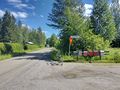
| − | + | 2024-07-13_65_25_03-road2.jpg|Not too promising traffic signs, but I should be able to proceed by bicycle. | |
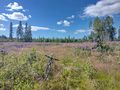
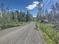
| + | 2024-07-13_65_25_04-road3.jpg|Gravel road at its worst. | ||
| + | 2024-07-13_65_25_05-bilberries.jpg|Bilberries are ripening but are still barely edible at best. | ||
| + | 2024-07-13_65_25_06-road4.jpg|Better road once again, from this point on familiar from [previous expedition]. | ||
| + | 2024-07-13_65_25_07-road5.jpg|Final field road towards the hashpoint, about 100 metres to go. | ||
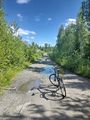
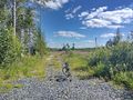
| + | 2024-07-13_65_25_08-bicycle.jpg|Bicycle parked next to the hashpoint. I was just barely able to ride all the way. | ||
| + | 2024-07-13_65_25_09-gpsr1.jpg|Hashpoint reached, proof of location. | ||
| + | 2024-07-13_65_25_10-gpsr2.jpg|Proof of date and time. | ||
| + | 2024-07-13_65_25_11-selfie.jpg|Selfie at the hashpoint. | ||
| + | 2024-07-13_65_25_12-lingonberries.jpg|Lingonberries are still raw. | ||
| + | 2024-07-13_65_25_13-road6.jpg|Rough gravel road. | ||
| + | 2024-07-13_65_25_14-river.jpg|The Kiiminkijoki river. | ||
</gallery> | </gallery> | ||
== Achievements == | == Achievements == | ||
| − | {{ | + | {{land geohash |
| − | + | | latitude=65 | |
| + | | longitude=25 | ||
| + | | date=2024-07-13 | ||
| + | | name=[[User:Kripakko|Kripakko]] | ||
| + | }} | ||
| + | {{bicycle geohash | ||
| + | | latitude=65 | ||
| + | | longitude=25 | ||
| + | | date=2024-07-13 | ||
| + | | name=[[User:Kripakko|Kripakko]] | ||
| + | | distance=103.7 km | ||
| + | | bothways=true | ||
| + | }} | ||
__NOTOC__ | __NOTOC__ | ||
Revision as of 11:34, 14 July 2024
| Sat 13 Jul 2024 in 65,25: 65.2166294, 25.5512527 geohashing.info google osm bing/os kml crox |
Location
In an open logging area near Onkamo, Haukipudas, Oulu.
The point on a topographic map: [1]
Participants
Expedition
Success! I will write a report later.
Tracklog
Photos
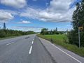
Highway 847 (old highway 4) towards Ii.
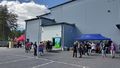
At the geocaching mega-event.
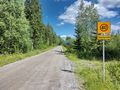
Not too promising traffic signs, but I should be able to proceed by bicycle.
Gravel road at its worst.
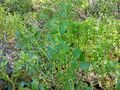
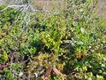
Bilberries are ripening but are still barely edible at best.
Better road once again, from this point on familiar from [previous expedition].
Final field road towards the hashpoint, about 100 metres to go.
Bicycle parked next to the hashpoint. I was just barely able to ride all the way.
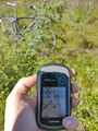
Hashpoint reached, proof of location.
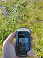
Proof of date and time.
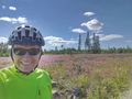
Selfie at the hashpoint.
Lingonberries are still raw.
Rough gravel road.
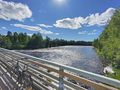
The Kiiminkijoki river.


Achievements
Kripakko earned the Land geohash achievement
|
Kripakko earned the Bicycle geohash achievement
|