Difference between revisions of "2008-08-30 34 -118"
imported>SouthLAMike (→Planning) |
imported>FippeBot m (Location) |
||
| (6 intermediate revisions by 3 users not shown) | |||
| Line 10: | Line 10: | ||
== Meetup location == | == Meetup location == | ||
| − | The meetup location is on a residential street in the Hollywood Hills near Benedict Canyon Rd. | + | The meetup location is on Summitridge Drive, a private, gated, residential street in the Hollywood Hills near Benedict Canyon Rd. |
| + | |||
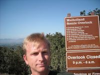
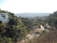
| + | [[User:SouthLAMike|Mike]] hit Mulholland Drive at 4:10pm and tried to find where the private Summitridge Drive connected. No success. It was one of handful of unlabeled, gated driveways. So, from the scenic overlook on Mulholland Drive, I took pictures of the canyon where the geohash was probably located. | ||
| + | |||
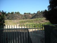
| + | From there, I drove down Benedict Canyon and up some windy streets to get to the west of the geohash location, where I managed to snap a photo in the direction of the geohash through someone's fence. | ||
| + | |||
| + | With no success, I got to the local Starbucks on Beverly Glen at about 4:30 and had a chai latte. | ||
| + | |||
| + | <gallery caption="Photo Gallery" widths="200px" heights="200px" perrow="2"> | ||
| + | Image:Mulholland1.jpg|Me on Mulholland Drive | ||
| + | Image:Mulholland2.jpg|View of hash from west | ||
| + | Image:Mulholland3.jpg|View of hash from Mulholland Drive to the north | ||
| + | </gallery> | ||
== Planning == | == Planning == | ||
| Line 21: | Line 33: | ||
* [[User:SouthLAMike|Mike]] plans to be there. | * [[User:SouthLAMike|Mike]] plans to be there. | ||
| − | [[Category: | + | [[Category:Expeditions]] |
| + | [[Category:Expeditions with photos]] | ||
| + | [[Category:Coordinates not reached]] | ||
| + | [[Category:Not reached - No public access]] | ||
| + | {{location|US|CA|LO}} | ||
Latest revision as of 06:42, 7 August 2019
| Sat 30 Aug 2008 in Los Angeles: 34.1190723, -118.4226173 geohashing.info google osm bing/os kml crox |
Meetup location
The meetup location is on Summitridge Drive, a private, gated, residential street in the Hollywood Hills near Benedict Canyon Rd.
Mike hit Mulholland Drive at 4:10pm and tried to find where the private Summitridge Drive connected. No success. It was one of handful of unlabeled, gated driveways. So, from the scenic overlook on Mulholland Drive, I took pictures of the canyon where the geohash was probably located.
From there, I drove down Benedict Canyon and up some windy streets to get to the west of the geohash location, where I managed to snap a photo in the direction of the geohash through someone's fence.
With no success, I got to the local Starbucks on Beverly Glen at about 4:30 and had a chai latte.
- Photo Gallery
Planning
Examination of Google Earth appears to show gatehouses across Summitridge Drive, so the actual hash is likely impossible.
So, the plan is to hit Summitridge Drive from the north (Mulholland Drive) side; drive as close to the hash as possible until stopped by gates; take quick picture before getting chased away by hyperprotective Hollywood Hills security guards; get cup of coffee at Beverly Glen Starbucks (2952 N Beverly Glen Cir, Los Angeles, CA).
People
- Mike plans to be there.


