Difference between revisions of "2008-09-06 39 -85"
imported>M5rammy m |
imported>James H m (fixed Category link) |
||
| Line 63: | Line 63: | ||
[[Category:Expeditions with photos]] | [[Category:Expeditions with photos]] | ||
[[Category:Coordinates not reached]] | [[Category:Coordinates not reached]] | ||
| − | [[Category:Failed - No | + | [[Category:Failed - No public access]] |
Revision as of 03:35, 9 September 2008
| Sat 6 Sep 2008 in 39,-85: 39.8999133, -85.1865472 geohashing.info google osm bing/os kml crox |
| Prev Sat Today |
Neighboring Meetups |
NW | N | NE |
| W | us | E | ||
| SW | S | SE |
The coordinates fell in farmland near Hagerstown, Indiana.
This was David, Sue, and Brett's second set of coordinates for the day. They came directly from 2008-09-06 39 -86, passing through the beautiful countryside outside of Indianapolis, Indiana. Unfortunately, they were unable to reach the graticule's precise coordinates. The path of greenery leading to the point visible in the satellite picture was inaccessible in person. Instead, the three geohashers got within 400 meters by reaching 39° 54' 6.04", -85° 10' 58.95" in a nearby cemetery.


The backup coordinates fell in a disused corner of the cemetery. A gravel access road led to a pile of dirt, broken cement fragments, and discarded plastic flowers. Beyond that was an overgrown and impassable drainage ditch.
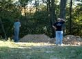
Dave and Sue looking for a path
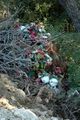
Discarded plastic flowers


Nevertheless, Sue placed a marker flag on top of one of the piles.

The marker flag and GPS showing their closest approach
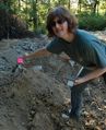
Sue placing the marker flag


Afterward, the three geohashers admired the cemetery's many interesting headstones. They found some dating back to the 1870s.
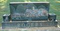
A very colorful and detailed headstone
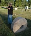
A large grindstone

