Difference between revisions of "2008-09-12 52 -0"
From Geohashing
imported>ReletBot m (Failed => Not reached) |
imported>Joehardflec (→Expedition) |
||
| Line 14: | Line 14: | ||
[[User:joehardflec |Joe Hardman]] went to this point by cycle, from his home village of Fleckney. The closest accessible (and viewable) point was the road to the south at 52.592617,-0.978051. | [[User:joehardflec |Joe Hardman]] went to this point by cycle, from his home village of Fleckney. The closest accessible (and viewable) point was the road to the south at 52.592617,-0.978051. | ||
| − | |||
| − | |||
<gallery perrow="3"> | <gallery perrow="3"> | ||
Revision as of 16:58, 5 October 2009
| Fri 12 Sep 2008 in Northampton, United Kingdom: 52.5959100, -0.9763374 geohashing.info google osm bing/os kml crox |
About
The location was in a field near King's Norton, Leics. The field was not public access, but a close location on the road was selected.
Expedition
Joe Hardman went to this point by cycle, from his home village of Fleckney. The closest accessible (and viewable) point was the road to the south at 52.592617,-0.978051.
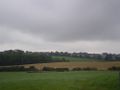
The hash location field viewed from the road location mentioned
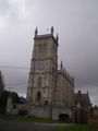
King's Norton Church, with bike near bench
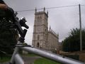
King's Norton Church, with bike close-up
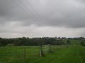
(I believe the stubble field in the background is the hash-location field too.) Taken from the village outskirts at 52.598665,-0.982521


