Difference between revisions of "2008-12-06 44 -93"
imported>Ademrudin (→Expedition) |
imported>Ademrudin (→Expedition) |
||
| Line 15: | Line 15: | ||
However, GPS failed to mention that this was 0.2 miles through a heavily wooded area, and mostly uphill. And there was a lake in the way. Have I mentioned that there was a lot of snow on the ground, it was well below freezing, and it was after sunset? | However, GPS failed to mention that this was 0.2 miles through a heavily wooded area, and mostly uphill. And there was a lake in the way. Have I mentioned that there was a lot of snow on the ground, it was well below freezing, and it was after sunset? | ||
| − | Temperature: High for the day was [http://www.wunderground.com/weatherstation/WXDailyHistory.asp?ID=KMNSAVAG1 27.8°F (-2.3°C)]. Temperature recorded from the nearest weather station as of my 5pm arrival time was ~15°F (-9.4°C) (See the weather graph on the previous link), which certainly is the [[Cold Geohash|coldest geohash on record]]. Unfortunately, no photographic evidence of a thermometer is to be had. | + | Temperature: High for the day was [http://www.wunderground.com/weatherstation/WXDailyHistory.asp?ID=KMNSAVAG1&month=12&day=6&year=2008 27.8°F (-2.3°C)]. Temperature recorded from the nearest weather station as of my 5pm arrival time was ~15°F (-9.4°C) (See the weather graph on the previous link), which certainly is the [[Cold Geohash|coldest geohash on record]]. Unfortunately, no photographic evidence of a thermometer is to be had. |
== Pictures == | == Pictures == | ||
Revision as of 01:34, 7 December 2008
| Sat 6 Dec 2008 in Minneapolis SW: 44.7112022, -93.3223535 geohashing.info google osm bing/os kml crox |
About
The location was approximately half a mile off of the nearest publicly accessible road, through dense woods. A weather report for the day can be seen here.
Expedition
Adem was the only participant. I set out around 4:00pm; drove down I-35 and got as near to the location as possible, the end of "Lynch Path". This turned out to be a private drive with no trespassing signs at the end of it, making the name even more ominous. I parked there anyway and set out. GPS claimed that the location was only about 0.2 miles away.
However, GPS failed to mention that this was 0.2 miles through a heavily wooded area, and mostly uphill. And there was a lake in the way. Have I mentioned that there was a lot of snow on the ground, it was well below freezing, and it was after sunset?
Temperature: High for the day was 27.8°F (-2.3°C). Temperature recorded from the nearest weather station as of my 5pm arrival time was ~15°F (-9.4°C) (See the weather graph on the previous link), which certainly is the coldest geohash on record. Unfortunately, no photographic evidence of a thermometer is to be had.
Pictures
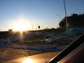
Setting out on the expedition at sunset
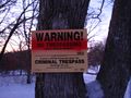
Hmmmm...
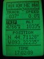
Location reached!
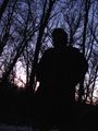
Victory! Hmmmm... It's getting colder and kinda dark out here...


