Difference between revisions of "2008-12-18 33 -96"
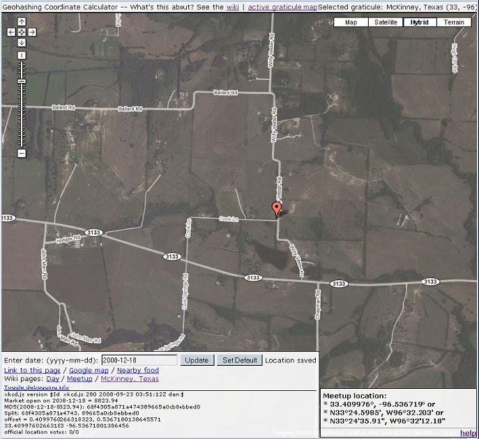
imported>Tyarra (New page: == Location == From the map, it appears to be an intersection of sorts. Farms? I'm newish to the area, so can't really recognize much from the satellite view. [[Image:Map-hybrid-2008-1...) |
imported>Tyarra |
||
| Line 1: | Line 1: | ||
| − | |||
== Location == | == Location == | ||
From the map, it appears to be an intersection of sorts. Farms? I'm newish to the area, so can't really recognize much from the satellite view. | From the map, it appears to be an intersection of sorts. Farms? I'm newish to the area, so can't really recognize much from the satellite view. | ||
| − | [[Image:Map-hybrid-2008-12-18. | + | [[Image:Map-hybrid-2008-12-18.JPG]] |
Revision as of 08:22, 19 December 2008
Location
From the map, it appears to be an intersection of sorts. Farms? I'm newish to the area, so can't really recognize much from the satellite view.
Participants
Expedition
Turns out, my very first day here, my home graticule has a location that appears to be reachable entirely by car. But, I started late ... by the time I got any idea at all of how to 'work' the map look up, I get a call from the SO, he's on his way home from work, and that's my cue to get dinner ready.
So... by the time I get a chance to sit down and look at things again, it's about 11pm local time. At first, I figure ... heck, I'll just wait until tomorrow, and see what the weekend locations around here look like. But, then, I take another look at the map, and it's actually an intersection of sorts. So ... why not?
My GPS is actually the Navigation application on my Blackberry, and you can't feed it coordinates, but you /can/ check to see what your current coordinates are -- given in the format that is listed last on the map look up.
