Difference between revisions of "2009-01-25 30 -81"
(New page: {{meetup graticule | map=<map lat="30" lon="-81" date="2009-01-25" /> | lat=30 | lon=-81 | date=2009-01-25 | graticule_name=Jacksonville, Florida | graticule_link=Jacksonville, Florida}}) |
|||
| Line 6: | Line 6: | ||
| graticule_name=Jacksonville, Florida | | graticule_name=Jacksonville, Florida | ||
| graticule_link=Jacksonville, Florida}} | | graticule_link=Jacksonville, Florida}} | ||
| + | |||
| + | ==Expeditions== | ||
| + | |||
| + | === Geohashers in Attendance === | ||
| + | |||
| + | * [[user:Woodveil|Woodveil]] | ||
| + | * [[user:Mr. Bow Tie|Mr. Bow Tie]] | ||
| + | * Easy | ||
| + | |||
| + | === The Chase === | ||
| + | |||
| + | Home for the weekend and armed with a brand-new Garmin GPS unit, [[user:Woodveil|Woodveil]] was finally equipped to do some more heavy-duty geohashing. I.E., we were excited about our newfound ability to simply walk into the woods and find a hashpoint. Which made this hashpoint ideal; it was located just off of I95, which would allow quick access, but would also require the use of dirt roads and a final hike into some woods to reach the hashpoint. Yay. | ||
| + | |||
| + | Meanwhile, [[user:Mr. Bow Tie|Mr. Bow Tie]] was also looking for his first successful hash, and so he and Woodveil decided to attempt the hash together. He was also pleasantly surprised when Woodveil, always a wildcard, made a brief detour on the way to the hash in order to make a small [[Drag-Along_Geohash|kidnapping]]. So now with a Nick, Chris, Mr. Bow Tie, and a captive, the party was finally headed towards the hash. A quick drive down some interstate went by swiftly and uneventfully, and some more geoSquishies were acquired at the exit, just in case. | ||
| + | |||
| + | The final stretch was the part we were still sketchy about. Dirt roads and forests. Or not…? Of course not. The whole party was pleased to find a paved road leading us towards the hash. Apparently much of a subdivision had been built since Google Maps' satellite image was taken. This ultimately proved to be an insurmountable obstacle, as that made the land private property. We were stopped in our tracks less than half a mile from our goal by <s>one</s> two no-tresspassing signs. Foiled again. No matter; we still had squishees. | ||
| + | |||
| + | == Gallery == | ||
| + | |||
| + | <gallery caption="Photo Gallery" widths="200px" heights="200px" perrow="3"> | ||
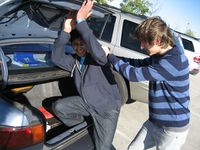
| + | Image:2009-01-18 kidnap.jpg|Our hostage. His name was Easy, and he turned out to be a really cool guy. | ||
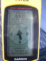
| + | Image:2009-01-18 gps.jpg|That's how close we got. | ||
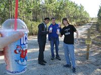
| + | Image:2009-01-18 everyone.jpg|There we are, geoSquishees and all. | ||
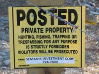
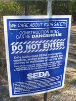
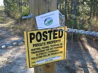
| + | Image:2009-01-18 sign3.jpg| There's one sign. Note the menacing-looking barbed-wire, lock and chains. | ||
| + | Image:2009-01-18 sign2.jpg| There's ''another'' sign. We figured they must be serious, and they must like signs. | ||
| + | Image:2009-01-18 our sign.jpg| So we added a third sign. | ||
| + | </gallery> | ||
| + | |||
| + | == Achievements == | ||
| + | |||
| + | {{No trespassing geohash | latitude = 30 | longitude = -81 | date = 2009-01-18| name = [[user:Woodveil|Woodveil]] and [[user:Mr. Bow Tie|Mr. Bow Tie]] }} | ||
| + | |||
| + | |||
| + | [[Category:Expeditions]] | ||
| + | [[Category:Expeditions with photos]] | ||
| + | [[Category:Coordinates not reached]] | ||
| + | [[Category:Failed - No public access]] | ||
Revision as of 17:14, 25 January 2009
| Sun 25 Jan 2009 in Jacksonville, Florida: 30.0374503, -81.4350494 geohashing.info google osm bing/os kml crox |
Expeditions
Geohashers in Attendance
- Woodveil
- Mr. Bow Tie
- Easy
The Chase
Home for the weekend and armed with a brand-new Garmin GPS unit, Woodveil was finally equipped to do some more heavy-duty geohashing. I.E., we were excited about our newfound ability to simply walk into the woods and find a hashpoint. Which made this hashpoint ideal; it was located just off of I95, which would allow quick access, but would also require the use of dirt roads and a final hike into some woods to reach the hashpoint. Yay.
Meanwhile, Mr. Bow Tie was also looking for his first successful hash, and so he and Woodveil decided to attempt the hash together. He was also pleasantly surprised when Woodveil, always a wildcard, made a brief detour on the way to the hash in order to make a small kidnapping. So now with a Nick, Chris, Mr. Bow Tie, and a captive, the party was finally headed towards the hash. A quick drive down some interstate went by swiftly and uneventfully, and some more geoSquishies were acquired at the exit, just in case.
The final stretch was the part we were still sketchy about. Dirt roads and forests. Or not…? Of course not. The whole party was pleased to find a paved road leading us towards the hash. Apparently much of a subdivision had been built since Google Maps' satellite image was taken. This ultimately proved to be an insurmountable obstacle, as that made the land private property. We were stopped in our tracks less than half a mile from our goal by one two no-tresspassing signs. Foiled again. No matter; we still had squishees.
Gallery
- Photo Gallery
Achievements
Woodveil and Mr. Bow Tie earned the No trespassing consolation prize
|
