Difference between revisions of "2009-02-07 45 -108"
From Geohashing
imported>David Souther |
imported>David Souther |
||
| Line 1: | Line 1: | ||
Successful Virgin Geohash. A field about 10mi N of Huntley, 3 mi NE of Shepherd. Gretchen and David left Rocky about 3pm, and after about 10 minutes through a muddy field were at the hash point at exactly 4 pm. Yay mud. 50 degrees, clear sky, gorgeous day. Snow, but not freezing. | Successful Virgin Geohash. A field about 10mi N of Huntley, 3 mi NE of Shepherd. Gretchen and David left Rocky about 3pm, and after about 10 minutes through a muddy field were at the hash point at exactly 4 pm. Yay mud. 50 degrees, clear sky, gorgeous day. Snow, but not freezing. | ||
| + | |||
| + | <gallery> | ||
| + | Image:2009-02_07_45_-108_Gretchen_trailblazing.jpg | Gretchen leading the way across a high berm canal separating two fields. | ||
| + | Image:2009-02-07_45_-108_proof.jpg | There was a slight misunderstanding between coordinates- I gave Gretchen seconds of arc, but the GPS only went to minutes of arc. Thus, we were off by about 25 feet- which was still the same field. | ||
| + | Image:2009-02-07_45_-108_David.jpg | With sundown at 5:30, 4 is getting kind of late. | ||
| + | Image:2009-02-07_45_-108_Gretchen_snow.jpg | It was very muddy. Gretchen decided to take the "solid" snow route. Snow is never solid. | ||
| + | </gallery> | ||
{{Virgin graticule | {{Virgin graticule | ||
Revision as of 01:47, 8 February 2009
Successful Virgin Geohash. A field about 10mi N of Huntley, 3 mi NE of Shepherd. Gretchen and David left Rocky about 3pm, and after about 10 minutes through a muddy field were at the hash point at exactly 4 pm. Yay mud. 50 degrees, clear sky, gorgeous day. Snow, but not freezing.
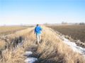
Gretchen leading the way across a high berm canal separating two fields.
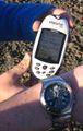
There was a slight misunderstanding between coordinates- I gave Gretchen seconds of arc, but the GPS only went to minutes of arc. Thus, we were off by about 25 feet- which was still the same field.
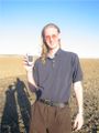
With sundown at 5:30, 4 is getting kind of late.
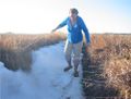
It was very muddy. Gretchen decided to take the "solid" snow route. Snow is never solid.


