Difference between revisions of "2009-06-28 38 -77"
From Geohashing
imported>Ben (New page: {{meetup graticule | map=<map lat="38" lon="-77" date="2009-06-28" /> | lat=38 | lon=-77 | date=2009-06-28 | graticule_name=Washington, DC (West) | graticule_link=Washington, DC }} ==The ...) |
imported>Jevanyn |
||
| Line 24: | Line 24: | ||
Image:2009-06-28-38-77-02.jpg|Myself in front of the selfsame site. A sign down the road warned of equestrians crossing. | Image:2009-06-28-38-77-02.jpg|Myself in front of the selfsame site. A sign down the road warned of equestrians crossing. | ||
</gallery> | </gallery> | ||
| + | |||
| + | [[Category:Expeditions]] | ||
| + | [[Category:Expeditions with photos]] | ||
Revision as of 14:38, 15 October 2009
| Sun 28 Jun 2009 in Washington, DC (West): 38.9102060, -77.3062207 geohashing.info google osm bing/os kml crox |
The Location
The site is located just off of Hunter's Valley road in Vienna, Virginia. It is on private property believed to be a horse pasture.
The Geohash
I am in the DC area for the summer, so I could not resist the opportunity to go geohashing in one of the area's plentiful graticules. The site is only a couple miles from the end of the orange line (Vienna/Fairfax stop). Although the area is quite suburban, Hunter's Valley Road gets pretty rural pretty quickly.
My camera is down for the count, so you will have to make do with old-cellphone-style pictures for the time being.
- Horsing Around
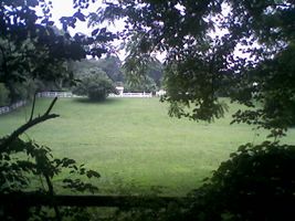
The site is in this field, beyond the fence.
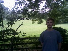
Myself in front of the selfsame site. A sign down the road warned of equestrians crossing.

