Difference between revisions of "2009-07-29 42 -83"
imported>Billsquared (→Expedition) |
imported>Billsquared |
||
| Line 7: | Line 7: | ||
== About == | == About == | ||
| − | Today's hash location | + | Today's hash location is in a garage on Bridge Park Drive in Troy, off Crooks Road between Square Lake Road and South Boulevard. |
| − | |||
| − | |||
| − | |||
| − | |||
| − | |||
| − | |||
| − | |||
| − | |||
| − | |||
| − | |||
== Expedition == | == Expedition == | ||
| − | + | Bill and son Brayden left home on foot (well, I was on foot, Brayden was fastened securely into the backpack carrier), with the hash location just under a mile as the crow flies from home. Seemed like a good time to snag a Walk Geohash achievement. | |
| − | |||
| − | Bill and son Brayden left home | ||
| − | |||
| − | |||
| − | |||
| − | |||
| − | |||
| − | |||
| − | |||
| − | |||
| − | |||
| − | |||
| − | |||
| − | |||
| − | |||
| − | |||
| − | |||
| − | |||
| − | |||
| − | |||
| − | |||
| − | |||
| − | |||
| − | |||
| − | |||
| − | |||
| − | |||
| − | |||
| − | |||
| − | |||
| − | |||
| − | |||
| − | |||
| − | |||
| − | |||
| − | |||
| − | |||
| − | |||
| − | |||
| − | |||
| − | |||
| − | |||
| − | |||
| − | |||
| − | |||
| − | |||
| − | + | I had really kind of hoped that there would be somebody home at the residence, to introduce them to Geohashing, and possibly encourage them to create an account and become the first official Couch Potato Hash. Alas, there was no answer at the doorbell, so I got my pictures of the GPS, the surroundings, and our grinning faces, and departed. (I did, however, leave my map printout with the main Geohashing page link on it, so if you see this, hello!) | |
== Pictures == | == Pictures == | ||
<gallery> | <gallery> | ||
| − | Image: | + | Image:Streetcorner_2009-08-26_42_-83.jpg | A view from the hash location to the corner of Bridge Park and Smith Court. |
| − | Image: | + | Image:Gps_2009-08-26_42_-83.jpg | The GPS fix as close as I could get to the actual coordinates without breaking and entering. |
| − | + | Image:Billbrayden_2009-08-26_42_-83.jpg | Our grinning faces, standing in the driveway. | |
| − | |||
</gallery> | </gallery> | ||
| − | {{ | + | {{Walk geohash |
| − | |||
| − | |||
| − | | latitude = 42 | + | | latitude = 42 |
| − | | longitude = -83 | + | | longitude = -83 |
| − | | date = 2009- | + | | date = 2009-08-26 |
| − | | | + | | name = Bill^2 |
| − | | | + | | distance = 4.8km (home-hash-home) |
| − | | | + | | image = Billbrayden_2009-08-26_42_-83.jpg |
}} | }} | ||
| − | |||
| − | |||
| − | |||
| − | |||
| − | |||
| − | |||
| − | |||
| − | |||
| − | + | [[Category: Meetup on 2009-08-26]] | |
| − | [[Category: Meetup on 2009- | ||
[[Category: Meetup in 42 -83]] | [[Category: Meetup in 42 -83]] | ||
Revision as of 01:18, 27 August 2009
| Wed 29 Jul 2009 in 42,-83: 42.5804344, -83.1123241 geohashing.info google osm bing/os kml crox |
About
Today's hash location is in a garage on Bridge Park Drive in Troy, off Crooks Road between Square Lake Road and South Boulevard.
Expedition
Bill and son Brayden left home on foot (well, I was on foot, Brayden was fastened securely into the backpack carrier), with the hash location just under a mile as the crow flies from home. Seemed like a good time to snag a Walk Geohash achievement.
I had really kind of hoped that there would be somebody home at the residence, to introduce them to Geohashing, and possibly encourage them to create an account and become the first official Couch Potato Hash. Alas, there was no answer at the doorbell, so I got my pictures of the GPS, the surroundings, and our grinning faces, and departed. (I did, however, leave my map printout with the main Geohashing page link on it, so if you see this, hello!)
Pictures
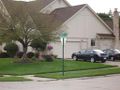
A view from the hash location to the corner of Bridge Park and Smith Court.
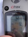
The GPS fix as close as I could get to the actual coordinates without breaking and entering.

Our grinning faces, standing in the driveway.


Bill^2 earned the Walk geohash Achievement
|