Difference between revisions of "2009-09-25 33 -116"
imported>Rs |
imported>Rs (→Photos) |
||
| Line 30: | Line 30: | ||
<gallery perrow="3"> | <gallery perrow="3"> | ||
| − | Image:2009-09-25 33 -116 Ramona Lake.jpg | Ramona Lake | + | Image:2009-09-25 33 -116 Ramona Lake.jpg | Ramona Lake. |
| − | Image:2009-09- | + | Image:2009-09-25 33 -116 Snail.jpg | A friendly snail. |
| − | Image:2009-09- | + | Image:2009-09-25 33 -116 Almost.jpg | Almost, but not quite. |
</gallery> | </gallery> | ||
Revision as of 19:50, 26 September 2009
| Fri 25 Sep 2009 in 33,-116: 33.0228332, -116.9926008 geohashing.info google osm bing/os kml crox |
Location
The meeting point was in an avocado tree farm just south of Lake Ramona, just a few meters away from 15500 Via Dena Loma, Ramona, CA.
Participants
Plans
Drive there and hopefully take a picture of the lake.
Expedition
Not having a boat car, I decided to go for the northeast graticule. Drove from Solana Beach through Poway, down progressively smaller and smaller roads. On the way there were hills covered in enormous boulders. I ended up parking about a half a mile away from the destination and walking down a dirt road covered in small avocados. There was some sort of farm to the left and another boulder-covered hill off to the right. The road ended at a fence with a beautiful view of Lake Ramona and a variety of avocado trees and stuff. Yay!
Tracklog
Photos
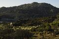
Ramona Lake.
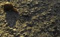
A friendly snail.
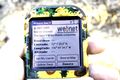
Almost, but not quite.


Results
The point itself was in the middle of a grove of trees behind barbed-wire fence, so I took a picture from 45 meters away.
Richard Soderberg earned the No trespassing consolation prize
|