Difference between revisions of "2009-11-08 44 -92"
imported>Rhonda (planning info.) |
imported>Rhonda (Thwarted in geohashing, but success in other adventures!) |
||
| Line 17: | Line 17: | ||
== Expedition == | == Expedition == | ||
| + | I managed to get away from work at 11:15, and headed basically due east. Google had me jog over to another road at one point, and when I got there I saw why. The road continued, but it went from country highway to small gravel road on the other side of the intersection. | ||
| + | I was to find out that this was common. | ||
| + | |||
| + | Eventually I found myself on 185th, which led almost directly to 500m away from the hashpoint, which was on the other side of a lake. 185th also turned to gravel, but this time a wide gravel road. Onward. | ||
| + | |||
| + | The road ended at a T-intersection with Ravenna, the hashpoint straight ahead, and google maps indicating parkland. What I saw was more fenced off farmland. | ||
| + | |||
| + | I went left (north) on Ravenna, and saw more farmland. Not just a single owner, either, who I could have asked permission; this was several different owners, and as I hadn't brought a printout of the google maps satellite view showing Ravenna and the lake, I couldn't ask some random person who owned the land the hashpoint was on. | ||
| + | |||
| + | [[Image:2009-11-08 44 -92 private-club.jpg|right|300px]] | ||
| + | I turned around and went south on Ravenna, and saw more farmland, then what looked like fairly unmodified land, but still fenced. Then I saw the most discouraging sign of all, and I had a guess as to who might own the treed and unimproved land on the other side of the lake. | ||
| + | |||
| + | I turned around again, and decided I was going to embark on the second part of today's journey: find and view the Mississippi River. | ||
| + | |||
| + | I followed Ravenna north again, with a memory and no printed maps of the river also going north. It was only noon; I had a picnic lunch in the back seat and more than four hours of daylight to burn in a rental car that my employer was paying for. | ||
| + | |||
| + | I found (in addition to lots of farms, which weren't so much found as ubiquitous) a river access that was a parking lot and a boat launch, with fenced private property on either side; the [http://www.carpenternaturecenter.org/ Carpenter St. Croix Valley Nature Centre], which overlooks the St. Croix river and not the Mississippi but whose staff kindly sketched a map for me to show me where to find a good spot to stop and see the Mississippi; and the aforementioned spot to stop and see the Mississippi, where it meets the St. Croix. | ||
| + | |||
| + | I ate my lunch on one of the lookout points in the nature centre's trail system, and enjoyed the view, and bought a few local varieties of apples that I had never heard of before from their orchard. Then I drove to the Mississippi view and sat on a park bench in the wonderfully warm sunshine and relaxed and wrote a bit more of my novel and took a picture of the beautiful sunny day to send to Vancouver, where it is rainy and miserable. | ||
| + | |||
| + | Then, because I didn't have a map and only realized I was actually in Wisconsin, not Minnesota, because the sign explaining the significance of this historic steamboat launch said so, I decided to retrace most of my route to get back to my hotel, so I didn't get trapped in Minneapolis/St. Paul highway interchange mazes. It mostly worked, although I took a parallel road a bit further north, and ended up facing another highway-becoming-dirt-road intersection. | ||
| + | |||
| + | PS: Minnesota - thank you for numbering your country roads in order, across multiple communities. Once I got up to the hundreds, I knew I could safely turn west and miss the big city, because I am staying in the 150-ish region :-) | ||
== Photos == | == Photos == | ||
| − | |||
| − | |||
| − | |||
| − | |||
| − | |||
<gallery> | <gallery> | ||
| − | + | Image:2009-11-08 44 -92 flat.jpg|Hm, the prairies are flat. Who knew? | |
| + | Image:2009-11-08 44 -92 so-close.jpg|So close, and yet... | ||
| + | Image:2009-11-08 44 092 not-a-park.jpg|it's not the park I was promised. | ||
| + | Image:2009-11-08 44 -92 private-club.jpg|no trespassing | ||
| + | Image:2009-11-08 44 -92 pretty-trail.jpg|So I went for a hike somewhere else, | ||
| + | Image:2009-11-08 44 -92 mississippi.jpg|and found the mighty Mississippi! | ||
</gallery> | </gallery> | ||
| − | |||
| − | |||
| − | |||
[[Category:Expeditions]] | [[Category:Expeditions]] | ||
| − | + | [[Category:Expeditions with photos]] | |
| − | [[Category:Expeditions with photos]] | ||
| − | |||
| − | |||
| − | |||
| − | |||
| − | |||
| − | |||
| − | |||
| − | |||
| − | |||
[[Category:Coordinates not reached]] | [[Category:Coordinates not reached]] | ||
| − | |||
| − | |||
[[Category:Not reached - No public access]] | [[Category:Not reached - No public access]] | ||
| − | |||
| − | |||
| − | |||
Revision as of 01:09, 9 November 2009
| Sun 8 Nov 2009 in 44,-92: 44.6808936, -92.7485891 geohashing.info google osm bing/os kml crox |
Location
In a park near the Mississippi river.
Participants
Plans
I intend to get away from work noonish then drive over and explore the park and see the Mississippi river, since I've never seen it before.
Expedition
I managed to get away from work at 11:15, and headed basically due east. Google had me jog over to another road at one point, and when I got there I saw why. The road continued, but it went from country highway to small gravel road on the other side of the intersection.
I was to find out that this was common.
Eventually I found myself on 185th, which led almost directly to 500m away from the hashpoint, which was on the other side of a lake. 185th also turned to gravel, but this time a wide gravel road. Onward.
The road ended at a T-intersection with Ravenna, the hashpoint straight ahead, and google maps indicating parkland. What I saw was more fenced off farmland.
I went left (north) on Ravenna, and saw more farmland. Not just a single owner, either, who I could have asked permission; this was several different owners, and as I hadn't brought a printout of the google maps satellite view showing Ravenna and the lake, I couldn't ask some random person who owned the land the hashpoint was on.

I turned around and went south on Ravenna, and saw more farmland, then what looked like fairly unmodified land, but still fenced. Then I saw the most discouraging sign of all, and I had a guess as to who might own the treed and unimproved land on the other side of the lake.
I turned around again, and decided I was going to embark on the second part of today's journey: find and view the Mississippi River.
I followed Ravenna north again, with a memory and no printed maps of the river also going north. It was only noon; I had a picnic lunch in the back seat and more than four hours of daylight to burn in a rental car that my employer was paying for.
I found (in addition to lots of farms, which weren't so much found as ubiquitous) a river access that was a parking lot and a boat launch, with fenced private property on either side; the Carpenter St. Croix Valley Nature Centre, which overlooks the St. Croix river and not the Mississippi but whose staff kindly sketched a map for me to show me where to find a good spot to stop and see the Mississippi; and the aforementioned spot to stop and see the Mississippi, where it meets the St. Croix.
I ate my lunch on one of the lookout points in the nature centre's trail system, and enjoyed the view, and bought a few local varieties of apples that I had never heard of before from their orchard. Then I drove to the Mississippi view and sat on a park bench in the wonderfully warm sunshine and relaxed and wrote a bit more of my novel and took a picture of the beautiful sunny day to send to Vancouver, where it is rainy and miserable.
Then, because I didn't have a map and only realized I was actually in Wisconsin, not Minnesota, because the sign explaining the significance of this historic steamboat launch said so, I decided to retrace most of my route to get back to my hotel, so I didn't get trapped in Minneapolis/St. Paul highway interchange mazes. It mostly worked, although I took a parallel road a bit further north, and ended up facing another highway-becoming-dirt-road intersection.
PS: Minnesota - thank you for numbering your country roads in order, across multiple communities. Once I got up to the hundreds, I knew I could safely turn west and miss the big city, because I am staying in the 150-ish region :-)
Photos
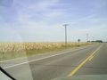
Hm, the prairies are flat. Who knew?
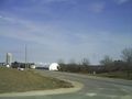
So close, and yet...
it's not the park I was promised.
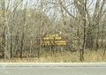
no trespassing
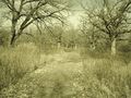
So I went for a hike somewhere else,
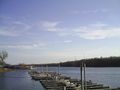
and found the mighty Mississippi!


