Difference between revisions of "2010-02-08 -37 145"
imported>Kozz (→Expedition) |
imported>Kozz (→Expedition) |
||
| Line 51: | Line 51: | ||
Anyway, I realised that the hashpoint was right on the opposite corner of the RDA area and there was simply no way that I could (a) morally justify trespassing or (b) actually get over any of the fences. I drove back to the carpark and tried to find the office for the RDA but the only thing nearby was a native plant nursery (which was closed) and I assume the gate next to it wasn't provided for people to access the agistment - the only way in / out would be through the approach road, for obvious reasons. | Anyway, I realised that the hashpoint was right on the opposite corner of the RDA area and there was simply no way that I could (a) morally justify trespassing or (b) actually get over any of the fences. I drove back to the carpark and tried to find the office for the RDA but the only thing nearby was a native plant nursery (which was closed) and I assume the gate next to it wasn't provided for people to access the agistment - the only way in / out would be through the approach road, for obvious reasons. | ||
| − | Took lots of photos of the pretty lake, including thousands of seagulls in a flotilla (I know that's not the proper collective noun but it suits this particular assembly) and attempted to take a panorama of the far-distant hashpoint through a chainlink fence. I drove around to the southern end of the reserve, but was blocked trying to get to the fence against which the hash was jammed - locked gate; private factory. Tried even further south in the hope that there would be another access road along the back of the factories as indicated on the map, but the other side of the approach road is an abandoned tip / quarry with massive no trespassing signs. What is it with [[2010-01- | + | Took lots of photos of the pretty lake, including thousands of seagulls in a flotilla (I know that's not the proper collective noun but it suits this particular assembly) and attempted to take a panorama of the far-distant hashpoint through a chainlink fence. I drove around to the southern end of the reserve, but was blocked trying to get to the fence against which the hash was jammed - locked gate; private factory. Tried even further south in the hope that there would be another access road along the back of the factories as indicated on the map, but the other side of the approach road is an abandoned tip / quarry with massive no trespassing signs. What is it with [[2010-01-19 -37 145 | geohashing in landfills and quarries]]?? |
Got home and realised [[user:MykaDragonBlue|Myka]] might've been in the same area at the same time, but I think he took a different approach road. Bummer, there's a good pub nearby. | Got home and realised [[user:MykaDragonBlue|Myka]] might've been in the same area at the same time, but I think he took a different approach road. Bummer, there's a good pub nearby. | ||
Revision as of 09:59, 8 February 2010
| Mon 8 Feb 2010 in -37,145: -37.9460294, 145.0871401 geohashing.info google osm bing/os kml crox |
Location
Participants
Plans
After work, I'll try to get to the hashpoint on the way home based on maps etc. Don't know how close I'll get, I can't figure out how easy it is to get onto the reserve with the hashpoint on it. Kozz 04:12, 8 February 2010 (UTC)
Not quite sure when, but i'm planing on driving down a little after work. I'll probably give the traffic a bit of time to lighten up first however. I'm not sure about getting to the actual point. both the reserve and the freight yard are fenced in, but I'm wondering if there is a gap between the reserve and the wasteland next to it, continuing on from Barkers St. There definitely appears to be a track along the powelines coming from the other direction, joining Henry St. If either of those routes are passable, then one could easily get within a few meters of the point. --mykaDragonBlue [- i have no sig -] 04:59, 8 February 2010 (UTC)
Expedition
Kozz - It looked so EASY...
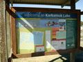
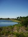
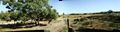
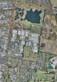
About 25 minutes drive from work and right in the corner of a CLEARLY MARKED RESERVE in Moorabin. I have no GPS at the moment, but the Google Earth satellite view showed a sizable lake, paths, and access roads all over the show. There was even a decent-sized road from South Road (a major-ish east-west arterial) that went all the way to within a few metres of the hashpoint. I printed off the relevant aerial view, maps and directions and had absolutely no issue finding the park, which turned out to be Karkarook Park, a pretty significant reserve wetland.
It was a scorcher of a day, and of course I was well-dressed for such an event - business shirt, suit trousers, tie, cufflinks, leather shoes - and it's 34 degrees outside and humid as hell. My initial foray was to be from the Karkarook Park carkpark, thinking I could cut straight through the marked reserve to the hashpoint, rather than taking the direct approach road all the way to the hashpoint.
Problem #1: 10-foot chainlink fence, topped with barbed wire.
OK, no problem. I'll walk around the northern side, see if I can wander down the approach road.
Problem #2: 10-foot chainlink fence, 2 x gates, both locked and padlocked.
OK, no problem. I'll walk to the start of the marked road and see if I can walk down the road.
Problem #3: No way to get to the road entrance unless I go back to the car, drive back around the outside of the park, onto South Road, then down the approach road.
OK, no problem. I'll walk back to the car, drive around to the approach road.
Problem #4: Approach road blocked, with a big 'Private Road - No Trespassing' and blue 'RDA' signs, on a 10-foot chainlink fence.
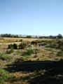
'RDA'. Why does that sound familiar? A long-forgotten subsection of memory clicked on in my brain, and I thought 'RDA. RDA. Riding...for the DisAbled.' It's a Riding for the Disabled reserve / agistment, including horse track - that's what I can see from the satellite photos! I thought it was a cycle track.
Riding for the Disabled is a voluntary organisation in Australia (and the rest of the world, I assume) that puts intellectually and physically handicapped children onto docile horses so they can experience what it's like to be mobile and to ride. I volunteered for a while with Special Olympics back in my hometown in NZ, and RDA was one of the few things that gave kids - especially those with physically limiting or degenerative diseases - the opportunity to experience interacting with animals of this size, and the independence of simply being able to move around without someone pushing them in a wheelchair or whatever. Without a doubt, they all loved it.
Anyway, I realised that the hashpoint was right on the opposite corner of the RDA area and there was simply no way that I could (a) morally justify trespassing or (b) actually get over any of the fences. I drove back to the carpark and tried to find the office for the RDA but the only thing nearby was a native plant nursery (which was closed) and I assume the gate next to it wasn't provided for people to access the agistment - the only way in / out would be through the approach road, for obvious reasons.
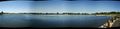
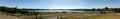
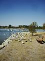
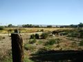
Took lots of photos of the pretty lake, including thousands of seagulls in a flotilla (I know that's not the proper collective noun but it suits this particular assembly) and attempted to take a panorama of the far-distant hashpoint through a chainlink fence. I drove around to the southern end of the reserve, but was blocked trying to get to the fence against which the hash was jammed - locked gate; private factory. Tried even further south in the hope that there would be another access road along the back of the factories as indicated on the map, but the other side of the approach road is an abandoned tip / quarry with massive no trespassing signs. What is it with geohashing in landfills and quarries??
Got home and realised Myka might've been in the same area at the same time, but I think he took a different approach road. Bummer, there's a good pub nearby.
Tracklog
Photos
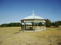
Official rotunda - viewable on satellite images
This is where I officially am
Clear, standing water? In Melbourne? That's unpossible!
The Karkarook Lake
Mate? Mate?
Wetlands, lovely
Horses, yay! Hashpoint thataway
RDA horseys
The hashpoint
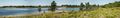
The lake
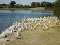
Seagulls flocking
The final fail point - no trespassing
Route taken - in from the east, out to the west, red = car, green = foot


.JPG)


