Difference between revisions of "2010-02-11 34.52 -110.10 (Unofficial)"
imported>Eylrid |
imported>Benjw (removing map to incorrect coordinates) |
||
| (14 intermediate revisions by 3 users not shown) | |||
| Line 1: | Line 1: | ||
| − | + | __NOTOC__ | |
| − | + | == Participants == | |
| − | + | * [[User:Eylrid|Eylrid]] | |
| − | |||
| − | |||
| − | |||
| − | |||
| − | + | == Plans == | |
| + | |||
| + | == Expedition == | ||
| + | <!-- how it all turned out. your narrative goes here. --> | ||
| + | This was my first expedition. I didn't have a way to get to the official hash, so I improvised. I used a point in a .05*.05 box: (34.527796 -110.103446). It turned out to be 6.5 km away. Even though none of it counts for anything official, I still did a few achievement like things. | ||
| + | |||
I traveled there by bicycle. Because I didn't have a GPS, and I took only the most rudimentary hand drawn map, when I got out into the boonies I got a bit confused about which dirt roads to take. Somehow I managed to find my way to a stopping spot that turns out to have been about 100 m away from my target. | I traveled there by bicycle. Because I didn't have a GPS, and I took only the most rudimentary hand drawn map, when I got out into the boonies I got a bit confused about which dirt roads to take. Somehow I managed to find my way to a stopping spot that turns out to have been about 100 m away from my target. | ||
| − | + | ||
I found a dump site near where I stopped. I had to crawl under a gate to get to my spot. | I found a dump site near where I stopped. I had to crawl under a gate to get to my spot. | ||
| − | + | ||
I left the "Internet Was Here" sign, took some pictures, and ate some food. | I left the "Internet Was Here" sign, took some pictures, and ate some food. | ||
| + | |||
| + | The view: I could see a lot of nothing. I could see a long ways, but it was mostly barren. | ||
| + | |||
| + | I had an awesome time! It was quite enjoyable! Geohashing is such a brilliant idea. I am looking forward to doing official expeditions. | ||
| + | |||
| + | ( More pictures later) | ||
| − | + | == Photos == | |
| + | <gallery perrow="4"> | ||
| + | Image:Dump_Close.JPG | Trash Heap. | ||
| + | </gallery> | ||
| − | + | [[Category:Unofficial expeditions]] | |
| − | + | <!--[[Category:Expeditions with photos]] | |
| + | [[Category:Expedition without GPS]] | ||
| − | [[Category: | + | [[Category:Coordinates not reached]] |
| + | [[Category:Not reached - Did not attempt]]--> | ||
Latest revision as of 16:36, 28 July 2010
Participants
Plans
Expedition
This was my first expedition. I didn't have a way to get to the official hash, so I improvised. I used a point in a .05*.05 box: (34.527796 -110.103446). It turned out to be 6.5 km away. Even though none of it counts for anything official, I still did a few achievement like things.
I traveled there by bicycle. Because I didn't have a GPS, and I took only the most rudimentary hand drawn map, when I got out into the boonies I got a bit confused about which dirt roads to take. Somehow I managed to find my way to a stopping spot that turns out to have been about 100 m away from my target.
I found a dump site near where I stopped. I had to crawl under a gate to get to my spot.
I left the "Internet Was Here" sign, took some pictures, and ate some food.
The view: I could see a lot of nothing. I could see a long ways, but it was mostly barren.
I had an awesome time! It was quite enjoyable! Geohashing is such a brilliant idea. I am looking forward to doing official expeditions.
( More pictures later)
Photos
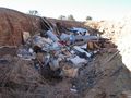
Trash Heap.
